Oga Quasi-National Park
Quasi-national park in Akita prefecture, Japan
From Wikipedia, the free encyclopedia
Oga Quasi-National Park (男鹿国定公園, Oga Kokutei Kōen) is a quasi-national park on the Oga Peninsula, in Akita Prefecture, in far northwestern Japan. The park is wholly within the city of Oga.[1][2][3][4][5] It is rated a protected landscape (Category V) according to the IUCN.[6]

| Oga Quasi-National Park | |
|---|---|
| 男鹿国定公園 | |
IUCN category V (protected landscape/seascape) | |
Mount Kanpū (355 m) | |
 Interactive map of Oga Quasi-National Park | |
| Location | Honshū, Japan |
| Nearest city | Oga, Akita Prefecture, Japan |
| Coordinates | 39°54′50″N 139°43′18″E |
| Area | 81.56 km2 (31.49 sq mi) |
| Established | 15 May 1973 |
| Governing body | Akita prefectural government[7] |
The area was designated a quasi-national park on May 15, 1973.[8]
Like all quasi-national parks in Japan, the park is managed by the local prefectural government; in this case, that of Akita prefecture.[7]
Godzilla Rock (Oga)
On the southern part of the Oga Peninsula, there is a place called Cape Shiosezaki.[9] One of the rocks there is nicknamed Godzilla Rock for its silhouette resembling Godzilla. (39°51′30.2″N 139°45′22.2″E) When the sun sets next to the natural formation, it can create the image of Godzilla blowing fire or more commonly known as radiation in the movies flame-blowing monster.[10] The other eroded and named rocks are Godzilla's Tail Rock, Gamera Rock, Turtle Rock, Twin Rocks and Sailboat Rock.[11][12]
Gallery
 Godzilla Rock signs
 2008
2008 2009
2009 2013
2013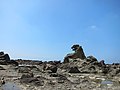 2013
2013 2020
2020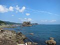 Sailboat Rock, height of 30m
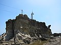 Shiosezaki Lighthouse on Turtle Rock


