Paha, Washington
From Wikipedia, the free encyclopedia
Paha, Washington | |
|---|---|
 Paha, Washington | |
| Coordinates: 47°01′24″N 118°29′21″W / 47.02333°N 118.48917°W | |
| Country | United States |
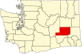
| State | Washington |
| County | Adams |
| Elevation | 1,565 ft (477 m) |
| Time zone | UTC-8 (Pacific (PST)) |
| • Summer (DST) | UTC-7 (PDT) |
| ZIP code | 99169 |
| Area code | 509 |
| GNIS feature ID | 1511212[1] |
Paha is an unincorporated community in Adams County, Washington, United States.[1] It is located along BNSF Railway's Lakeside Subdivision. Paha is assigned the ZIP code 99169.
A post office called Paha was established in 1886, and remained in operation until 1943.[2] The name Paha is Indian in origin.[3]