Pescocostanzo
Comune in Abruzzo, Italy
From Wikipedia, the free encyclopedia
Pescocostanzo is a comune and town of 1038 inhabitants in the Province of L'Aquila in the Abruzzo region of Italy. It is a tourist destination, attracting people from all over Italy due to its landscape and environment.[citation needed] It is part of the Maiella National Park and is one of I Borghi più belli d'Italia ("The most beautiful villages of Italy").[3] In winter, Pescocostanzo is a destination for skiers and snowboarders, and has its own ski resort. The towns of Roccaraso and Rivisondoli are close by.

Pescocostanzo | |
|---|---|
| Comune di Pescocostanzo | |
| |
 Pescocostanzo Location of Pescocostanzo in Italy  Pescocostanzo Pescocostanzo (Abruzzo) | |
| Coordinates: 41°53′14″N 14°3′59″E | |
| Country | Italy |
| Region | Abruzzo |
| Province | L'Aquila (AQ) |
| Frazioni | Sant'Antonio Bosco |
| Area | |
• Total | 52.16 km2 (20.14 sq mi) |
| Elevation | 1,395 m (4,577 ft) |
| Population (1 January 2007)[2] | |
• Total | 1,196 |
| • Density | 22.93/km2 (59.39/sq mi) |
| Demonym | Pescolani |
| Time zone | UTC+1 (CET) |
| • Summer (DST) | UTC+2 (CEST) |
| Postal code | 67033 |
| Dialing code | 0864 |
| ISTAT code | 066070 |
| Patron saint | San Felice |
| Saint day | 8 August |
| Website | Official website |
Gallery
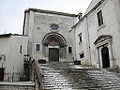 Basilica della Madonna del Colle
 Palazzo Fanzago


Climate
| Climate data for Pescocostanzo, elevation 1,371 m (4,498 ft), (1991-2020) | |||||||||||||
|---|---|---|---|---|---|---|---|---|---|---|---|---|---|
| Month | Jan | Feb | Mar | Apr | May | Jun | Jul | Aug | Sep | Oct | Nov | Dec | Year |
| Record high °C (°F) | 14.2 (57.6) |
17.0 (62.6) |
19.2 (66.6) |
21.5 (70.7) |
26.5 (79.7) |
30.0 (86.0) |
33.5 (92.3) |
33.5 (92.3) |
30.5 (86.9) |
23.5 (74.3) |
19.9 (67.8) |
17.1 (62.8) |
33.5 (92.3) |
| Mean daily maximum °C (°F) | 3.3 (37.9) |
3.4 (38.1) |
6.5 (43.7) |
10.6 (51.1) |
15.1 (59.2) |
19.5 (67.1) |
22.4 (72.3) |
22.9 (73.2) |
17.2 (63.0) |
13.7 (56.7) |
8.5 (47.3) |
4.0 (39.2) |
12.3 (54.1) |
| Daily mean °C (°F) | 0.5 (32.9) |
0.3 (32.5) |
3.2 (37.8) |
6.7 (44.1) |
11.0 (51.8) |
15.1 (59.2) |
17.7 (63.9) |
18.1 (64.6) |
13.2 (55.8) |
10.0 (50.0) |
5.4 (41.7) |
1.3 (34.3) |
8.5 (47.3) |
| Mean daily minimum °C (°F) | −2.3 (27.9) |
−2.8 (27.0) |
−0.2 (31.6) |
2.9 (37.2) |
6.8 (44.2) |
10.6 (51.1) |
13.0 (55.4) |
13.4 (56.1) |
9.1 (48.4) |
6.4 (43.5) |
2.4 (36.3) |
−1.3 (29.7) |
4.8 (40.6) |
| Record low °C (°F) | −18.5 (−1.3) |
−15.6 (3.9) |
−14.5 (5.9) |
−10.2 (13.6) |
−5.5 (22.1) |
0.0 (32.0) |
1.2 (34.2) |
2.0 (35.6) |
−2.0 (28.4) |
−7.0 (19.4) |
−12.0 (10.4) |
−18.8 (−1.8) |
−18.8 (−1.8) |
| Source 1: Istituto Superiore per la Protezione e la Ricerca Ambientale[4] | |||||||||||||
| Source 2: Regione Abruzzo[5] | |||||||||||||