Petty, Georgia
From Wikipedia, the free encyclopedia
Petty, Georgia | |
|---|---|
 Petty  Petty | |
| Coordinates: 31°15′37″N 84°09′22″W / 31.26039°N 84.15611°W | |
| Country | United States |
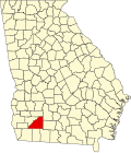
| State | Georgia |
| County | Mitchell |
| Time zone | UTC-5 (Eastern (EST)) |
| • Summer (DST) | UTC-4 (EDT) |
| Area code | 229 |
Petty is an unincorporated community located in Mitchell County, Georgia, United States.[1]
Petty's latitude is at 31.178517 and its longitude is at -84.1679591. Petty lies at the end of Ironweed Road. Mayhaw Lane, Midway Road, Back 9 Road, Old Georgia Highway/Route 3, Hog Haw Road, Mount Zion Church Road, Microwave Road, and US Route 19 run through the area. Howell Lake is the area's primary water source.[1]
Churches
Pleasant View Missionary Baptist Church is the area's church.[1]
Demographics
As of 2011 Petty is a small farming community.