Plate, Germany
From Wikipedia, the free encyclopedia
Plate | |
|---|---|
 Coat of arms | |
Location of Plate
within Ludwigslust-Parchim district
| |
 Plate  Plate | |
| Coordinates: 53°33′N 11°30′E / 53.550°N 11.500°E | |
| Country | Germany |
| State | Mecklenburg-Vorpommern |
| District | Ludwigslust-Parchim |
| Municipal assoc. | Crivitz |
| Subdivisions | 3 |
| Government | |
| • Mayor | Ronald Radscheidt |
| Area | |
• Total | 22.14 km2 (8.55 sq mi) |
| Elevation | 38 m (125 ft) |
| Population (2023-12-31)[1] | |
• Total | 3,391 |
| • Density | 153.2/km2 (396.7/sq mi) |
| Time zone | UTC+01:00 (CET) |
| • Summer (DST) | UTC+02:00 (CEST) |
| Postal codes | 19086 |
| Dialling codes | 03861 |
| Vehicle registration | LUP, PCH |
| Website | www.gemeinde-plate.de |

Plate (German pronunciation: [ˈplaːtə]) is a municipality in the Ludwigslust-Parchim district, in Mecklenburg-Vorpommern, Germany.
 Church
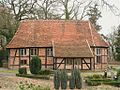 Church
 Church
 Stör-channel
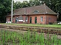 Train station


