Potton Brook
From Wikipedia, the free encyclopedia
CountryEngland
CountiesBedfordshire, Cambridgeshire
Unitary AuthorityCentral Bedfordshire
locationeast of Gamlingay, Cambridgeshire, England
| Potton Brook | |
|---|---|
 Horse Brook tributary to Potton Brook on west side of Henry Smith Playfields, Potton | |
 | |
| Location | |
| Country | England |
| Counties | Bedfordshire, Cambridgeshire |
| Unitary Authority | Central Bedfordshire |
| Physical characteristics | |
| Source | |
| • location | east of Gamlingay, Cambridgeshire, England |
| • coordinates | 52°9′5.13″N 0°9′39.54″W / 52.1514250°N 0.1609833°W |
| Mouth | |
• location | Bedfordshire, England |
• coordinates | 52°6′48″N 0°16′37″W / 52.11333°N 0.27694°W |
• elevation | 25 m (82 ft) |
| Length | 15.656 km (9.728 mi)[1] |
| Discharge | |
| • location | Sandy |
Potton Brook rises east of Gamlingay, Cambridgeshire, and flows southwest and then south through Potton[2] and the John O'Gaunt Golf Club and into Sutton, Bedfordshire. Potton Brook curves west and northwest, and joins the River Ivel northeast of Lower Caldecote. It has a total length of 15.656 km (9.728 mi).[3][4]
Potton Brook flows along the West Boundary of the Henry Smith playing fields in Potton. On West side of the playing fields is the smaller Horse Brook which flows into Potton Brook.
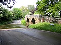 A packhorse bridge and ford across Potton Brook at Sutton in Bedfordshire
