Pretzfeld
From Wikipedia, the free encyclopedia
Pretzfeld | |
|---|---|
 Coat of arms | |
Location of Pretzfeld
within Forchheim district 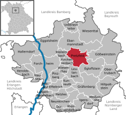 | |
 Location of Pretzfeld | |
 Pretzfeld  Pretzfeld | |
| Coordinates: 49°45′N 11°10′E / 49.750°N 11.167°E | |
| Country | Germany |
| State | Bavaria |
| Admin. region | Oberfranken |
| District | Forchheim |
| Subdivisions | 13 Ortsteile |
| Government | |
| • Mayor (2020–26) | Steffen Lipfert[1] |
| Area | |
• Total | 24.21 km2 (9.35 sq mi) |
| Elevation | 293 m (961 ft) |
| Population (2023-12-31)[2] | |
• Total | 2,383 |
| • Density | 98.43/km2 (254.9/sq mi) |
| Time zone | UTC+01:00 (CET) |
| • Summer (DST) | UTC+02:00 (CEST) |
| Postal codes | 91362 |
| Dialling codes | 09194 |
| Vehicle registration | FO |
| Website | www.Pretzfeld.de |
Pretzfeld (German pronunciation: [ˈpʁɛtsfɛlt]) is a municipality in the district of Forchheim in Bavaria in Germany.
Geographical location
The municipality is located in the south-western part of Upper Franconia, in Franconian Switzerland. The region is known for growing and processing fruit. Of the approx. 2500 ha total area, 1100 ha are forest. The town of Pretzfeld lies in the west of the municipality, near the confluence of the Trubach and the Wiesent.
Districts
The pretzfeld municipality has 13 districts:[3]
