Puerto Rico Highway 26
Highway in Puerto Rico
From Wikipedia, the free encyclopedia
Puerto Rico Highway 26 (PR-26),[a] called the Román Baldorioty de Castro Expressway, is the main highway to the Luis Muñoz Marín International Airport and is connected to PR-66.[2] It was converted to a freeway to minimize the traffic in PR-3 and PR-17, to grant better access to the Airport.[3][4] Several exits exist to provide access to PR-187 (the main route to the Piñones area), PR-37 (Isla Verde) and PR-22 (José de Diego).[5] PR-26 is 15.1 km (9.4 mi) long.[6]

Length15.1 km[1] (9.4 mi)
Existed1982 and completed in 1999[citation needed]–present
Highway 26 | ||||
|---|---|---|---|---|
| Ruta 26 | ||||
| Expreso Román Baldorioty de Castro | ||||
| Route information | ||||
| Maintained by Puerto Rico DTPW | ||||
| Length | 15.1 km[1] (9.4 mi) | |||
| Existed | 1982 and completed in 1999[citation needed]–present | |||
| Major junctions | ||||
| West end | ||||
| East end | ||||
| Location | ||||
| Country | United States | |||
| Territory | Puerto Rico | |||
| Municipalities | San Juan, Carolina | |||
| Highway system | ||||
| ||||
 San Antonio Bridge in PR-26
 PR-26 in Condado
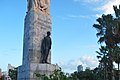 Román Baldorioty de Castro Statue in PR-26
 PR-26 in Isla Verde
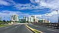
 Puerto Rico Highway 26 in Isla Verde
.jpg)
.jpg)


Exit list
 Expreso Román Baldorioty de Castro Salida 7
 PR-26 in Carolina after Hurricane Maria (September 20, 2017)
 PR-26 towards PR-66 and PR-3
 Puerto Rico Highway 66 becomes PR-26 in Carolina after the exit to PR-3

.jpg)


| Municipality | Location | km[1] | mi | Exit | Destinations | Notes |
|---|---|---|---|---|---|---|
| San Juan | Santurce | 0.0 | 0.0 | — | Western terminus of PR-26 | |
| 0.3 | 0.19 | — | PR-Marginal Román Baldorioty de Castro – Santurce | Eastbound exit only; one-way street | ||
| 1.4– 1.5 | 0.87– 0.93 | 1 | Eastbound exit signed as 1A | |||
| 1.7– 1.8 | 1.1– 1.1 | 1B | PR-Calle Canals – Condado, Parada 19 | Eastbound exit only; one-way street | ||
| 2.0– 2.1 | 1.2– 1.3 | 2A | Túnel Minillas | |||
| 2.3– 2.4 | 1.4– 1.5 | 2B | ||||
| 3.0– 4.1 | 1.9– 2.5 | 4 | PR-Calle Degetau / PR-Calle Providencia / PR-Calle Tapia – Ocean Park | Westbound exit signed as 4A | ||
| 4.6 | 2.9 | 4B | Westbound exit only | |||
| Carolina | Cangrejo Arriba | 5.4 | 3.4 | 5 | Westbound exit only | |
| 5.5– 6.5 | 3.4– 4.0 | 6 | ||||
| 7.3 | 4.5 | 7 | ||||
| 7.7 | 4.8 | 8A | Toll bridge | |||
| 8B | ||||||
| 9.1 | 5.7 | 9 | PR-Avenida Los Ángeles – Carolina | Eastbound exit signed as 9A | ||
| 9.5 | 5.9 | 9B | PR-Marginal Los Ángeles – Carolina | Eastbound exit only | ||
| 11.1– 11.2 | 6.9– 7.0 | 11 | Eastbound exit and westbound entrance | |||
| Sabana Abajo | 12.5 | 7.8 | 12 | PR-Avenida Roberto Sánchez Vilella – Carolina, Country Club | Eastbound exits are signed as 12A (west) and 12B (east) | |
| 13.6 | 8.5 | 13 | Eastbound exits are signed as 13A (west) and 13B (east) | |||
| 14.8– 14.9 | 9.2– 9.3 | 14 | PR-Avenida Jesús M. Fragoso – Carolina | Eastbound exit and entrance | ||
| San Antón | 15.1 | 9.4 | 15A | Eastern terminus of PR-26 | ||
| 15B | ||||||
| 1.000 mi = 1.609 km; 1.000 km = 0.621 mi | ||||||
See also
Notes
- PR-26 is the unsigned Interstate PRI3