Quincy, Kansas
From Wikipedia, the free encyclopedia
Quincy, Kansas | |
|---|---|
 | |
 Quincy  Quincy | |
| Coordinates: 37°52′55″N 95°59′34″W / 37.88194°N 95.99278°W[1] | |
| Country | United States |
| State | Kansas |
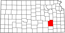
| County | Greenwood |
| Elevation | 942 ft (287 m) |
| Time zone | UTC-6 (CST) |
| • Summer (DST) | UTC-5 (CDT) |
| Area code | 620 |
| FIPS code | 20-58150 |
| GNIS ID | 474454 [1] |
Quincy is an unincorporated community in Greenwood County, Kansas, United States.[1] It is located between Eureka and Yates Center in a rural area.
A post office was opened in Quincy in 1869, and remained in operation until it was discontinued in 1975.[2] In the mid-20th Century, after surviving a severe flood of the Verdigris River, it had a bank, school, church, grocery store, and telephone exchange. The Great Depression and World War II II led to the migration of many to larger communities in search of work, particularly in the war factories in the region, especially Wichita.[3][4]
Education
This community and nearby rural areas are served by Hamilton USD 390 public school district.