Rangamati District
District in Chattogram Division, Bangladesh
From Wikipedia, the free encyclopedia
Rangamati District (Bengali: রাঙ্গামাটি জেলা), officially Rangamati Hill District, is a district in the south-eastern Chittagong Hill Tracts of Bangladesh. It is a part of the Chattogram Division.[4] The town of Rangamati is known as the capital of the Chittagong Hill Tracts. By area, Rangamati is the largest district of the country.

Rangamati Hill District
রাঙামাটি পার্বত্য জেলা | |
|---|---|
View of the Sajek Valley | |
| Motto: বাংলাদেশ চিরজীবী হোক | |
 Location of Rangamati District within Bangladesh | |
 Expandable map of Rangamati District | |
| Coordinates: 22°38′N 92°12′E | |
| Country |  Bangladesh Bangladesh |
| Division | Chittagong Division |
| Capital | Rangamati |
| Government | |
| • Type | District Council |
| • Body | Rangamati Hill District Council |
| Area | |
• Total | 6,116.11 km2 (2,361.44 sq mi) |
| • Land | 4,824.63 km2 (1,862.80 sq mi) |
| • Water | 1,291.5 km2 (498.7 sq mi) |
| • Rank | 1 (Largest District of Bangladesh) |
| Elevation | 17 m (56 ft) |
| Population | |
• Total | 647,586 |
| • Rank | 62 (Among 64) |
| • Density | 134.225/km2 (347.641/sq mi) |
| Time zone | UTC+6 (BST) |
| Postal Code | 4500 |
| Area code | 0351 |
| ISO 3166 code | BD-56 |
| HDI (2023) | 0.630[3] medium · 21st of 22 |
| Website | www |
| Population & Area related info taken from রাঙ্গামাটি জেলা তথ্য বাতায়নে আপনাকে স্বাগতম [Welcome to the Rangamati district portal]. Deputy Commissioner Rangamati (in Bengali). Archived from the original on 17 January 2013. | |
Geography
Rangamati is located in the Chittagong Division. It is bordered by the Tripura state of India to the north, Bandarban District to the south, Mizoram State of India and Chin State of Myanmar to the east, and Khagrachari and Chittagong Districts to the west. Rangamati is the only district in Bangladesh with international borders with two countries: India and Myanmar.
The area of the district is 6,116 km2 of which 1,292 km2 is riverine and 4,825 km2 is under forest vegetation.
History
Rangamati was a contesting ground for the kings of Tripura and Arakan. In 1737, Sher Mosta Khan, a tribal leader, took refuge with the Mughals. Subsequently, the Chakma settlement began along with various other settlements of varying ethnicity.[5] From 1760 to 1761, the area was leased to the East India Company.[5]
Demography
According to the 2022 Census of Bangladesh, Rangamati Hill District had 153,482 households and a population of 647,586 with an average of 4.15 people per household. Among the population, 119,027 (18.38%) inhabitants were under 10 years of age. The population density was 106 people per km2. The literacy rate (age 7 and over) was 71.41%, compared to the national average of 74.80%. The sex ratio of the district was at 106 males per 100 females. Approximately 47.56% of the population lived in urban areas.[7][2]
According to the 2022 census, there were a total of 372,875 (57.58%) tribal people in the district. The populations of major ethnic minorities are Chakma 276,048, Marma 51,403, Tanchangya 27,975, Tripura 12,300, Khyang 1,670, and Pankhu 1,398.[8]
| Upazila | Bengali | Chakma | Marma | Tanchangya | Others |
|---|---|---|---|---|---|
| Bagaichhari | 28.2 % | 66.2% | 0.08% | 0.01% | 5.51% |
| Barkal | 29.0 % | 69.3 % | 0.88% | 0.03% | 0.79% |
| Belaichhari | 15.9% | 26.7% | 8.97% | 38.77% | 9.66% |
| Juraichhari | 4.65% | 91.2% | 0.28% | 3.33% | 0.54% |
| Kaptai | 55.7% | 2.25% | 28.6% | 12.42% | 1.03% |
| Kawkhali | 44.9% | 25.9% | 27.9% | 1.02% | 0.28% |
| Langadu | 76.5% | 23.1% | 0.01% | 0.01 | 0.38% |
| Naniarchar | 18.3% | 79.9 % | 1.74% | 0.01% | 0.05% |
| Rajasthali | 32.3 % | 0.97% | 36.6% | 16.30% | 13.83% |
| Sadar | 52.3% | 41.2% | 1.89% | 2.38% | 2.23% |

| Upazila | Union | Bengali | Chakma | Marma | Tanchangya | Others |
|---|---|---|---|---|---|---|
| Sadar | Rangamati Paurashava | 71,741 | 29,334 | 1,743 | 1,208 | 2,034 |
| Balukhali | 598 | 5,684 | 138 | 522 | 1,021 | |
| Bandukbhanga | 93 | 7,043 | 8 | 1 | 15 | |
| Jibtali | 1,706 | 1,961 | 535 | 250 | 0 | |
| Kutukchhari | 279 | 6,310 | 14 | 5 | 42 | |
| Magban | 595 | 5,087 | 310 | 1,497 | 5 | |
| Sapchhari | 1,696 | 5,030 | 17 | 5 | 64 | |
| Baghaichhari | Baghaichhari Paurashava | 13,319 | 2,223 | 3 | 0 | 99 |
| Amtali | 5,700 | 0 | 0 | 0 | 3 | |
| Baghaichhari | 1,670 | 8,139 | 12 | 0 | 5 | |
| Bangaltali | 2,118 | 8,684 | 7 | 0 | 7 | |
| Khedarmara | 2,092 | 8,343 | 8 | 1 | 33 | |
| Marishya | 1,189 | 4,746 | 2 | 0 | 11 | |
| Rupakari | 515 | 4,284 | 1 | 0 | 5 | |
| Sajek | 3,198 | 22,484 | 31 | 1 | 5,671 | |
| Saroatali | 193 | 11,448 | 25 | 10 | 4 | |
| Langadu | Atarakchhara | 5,995 | 7,148 | 2 | 2 | 24 |
| Bagachatar | 13,248 | 1,347 | 1 | 0 | 47 | |
| Bhasanyadam | 6,582 | 908 | 0 | 0 | 2 | |
| Gulshakhali | 10382 | 986 | 0 | 0 | 260 | |
| Kalapakujya | 8625 | 0 | 0 | 0 | 0 | |
| Langadu | 6,226 | 9,595 | 6 | 2 | 5 | |
| Mainimukh | 18,100 | 904 | 4 | 0 | 5 | |
| Barkal | Aimachhara | 1,376 | 6,137 | 6 | 4 | 16 |
| Bara Harina | 362 | 5,426 | 4 | 0 | 178 | |
| Barkal | 2,497 | 4,428 | 221 | 4 | 116 | |
| Bhushanchhara | 6,829 | 9,985 | 186 | 5 | 41 | |
| Subalong | 3,428 | 8,486 | 19 | 5 | 48 | |
| Kaptai | Chandraghona | 8,234 | 115 | 326 | 292 | 226 |
| Chitmaram | 1,323 | 125 | 3,441 | 407 | 142 | |
| Kaptai | 11,663 | 831 | 715 | 1,561 | 142 | |
| Raikhali | 6,382 | 126 | 8,244 | 1,154 | 18 | |
| Wagga | 3,263 | 49 | 3,118 | 3,467 | 44 | |
| Belaichhari | Barathali | 582 | 6 | 490 | 1,087 | 1,430 |
| Belaichhari | 1,335 | 3,434 | 556 | 2,949 | 389 | |
| Farua | 1,326 | 983 | 1,012 | 7,016 | 1,048 | |
| Kengrachhari | 1,445 | 3,459 | 592 | 400 | 1 | |
| Juraichhari | Bonjogichhara | 326 | 4,945 | 13 | 4 | 9 |
| Dumdumya | 234 | 6,678 | 33 | 594 | 126 | |
| Juraichhari | 563 | 8,761 | 9 | 13 | 23 | |
| Maidang | 128 | 4,164 | 20 | 287 | 2 | |
| Kawkhali | Betbunia | 12,503 | 601 | 6,372 | 16 | 27 |
| Fatikchhari | 11 | 3,278 | 2,497 | 2 | 44 | |
| Ghagra | 8,851 | 12,177 | 3,290 | 655 | 94 | |
| Kalampati | 8,394 | 1,132 | 6,318 | 4 | 44 | |
| Naniarchar | Burighat | 6,154 | 6,893 | 759 | 0 | 24 |
| Ghilachhari | 551 | 8,783 | 28 | 1 | 4 | |
| Naniarchar | 1,341 | 11,619 | 50 | 1 | 19 | |
| Sabekkyong | 116 | 11,471 | 5 | 0 | 2 | |
| Rajasthali | Bangalhalia | 6,070 | 133 | 4,161 | 274 | 310 |
| Gaindya | 1,492 | 76 | 5,330 | 1,157 | 470 | |
| Ghilachhari | 1,447 | 60 | 722 | 3,111 | 3,051 |
| Ethnic group | Union | Municipality | Upazila |
|---|---|---|---|
| Bengali | 11 | 2 | 4 |
| Chakma | 32 | 0 | 3 |
| Marma | 3 | 0 | 1 |
| Tanchangya | 3 | 0 | 1 |
| Tripura | 1 | 0 | 0 |
| Total | 50 | 2 | 10 |
Bengalis
According to the 2022 census, Bengalis are the second-largest ethnic group in Rangamati Hill District (42.42%), nearly as numerous as Chakma people (42.63%).[9]
By Upazila
| Upazila | Population | Percentage of Bengalis[9] |
|---|---|---|
| Langadu Upazila | 69,160 | 76.50% |
| Kaptai Upazila | 30,867 | 55.71% |
| Rangamati Sadar Upazila | 76,718 | 52.33% |
| Kawkhali Upazila | 29,763 | 44.88% |
| Rajasthali Upazila | 9,009 | 32.33% |
| Barkal Upazila | 14,393 | 28.96% |
| Bagaichhari Upazila | 29,998 | 28.22% |
| Naniarchar Upazila | 8,864 | 18.27% |
| Belaichhari Upazila | 4,688 | 15.87% |
| Juraichhari Upazila | 1,251 | 4.65% |
By Union (Highest 10)
| Union | Upazila | Percentage |
|---|---|---|
| Kalapakujya Union | Langadu Upazila | 100% |
| Amtali Union | Baghaichhari Upazila | 99.95% |
| Mainimukh Union | Langadu Upazila | 95.2% |
| Bagachatar Union | Langadu Upazila | 90.47% |
| Chandraghona Union | Kaptai Upazila | 89.57% |
| Gulshakhali Union | Langadu Upazila | 89.28% |
| Bhasanyadam Union | Langadu Upazila | 87.85% |
| Kaptai Union | Kaptai Upazila | 78.2% |
| Betbunia Union | Kawkhali Upazila | 64% |
| Bangalhalia Union | Rajasthali Upazila | 55.4% |

Chakmas
According to the 2022 census, Chakmas are the largest ethnic group in Rangamati District (42.63%).[7]
By Upazila
| Upazila | Population | Percentage of Chakmas[7] |
|---|---|---|
| Juraichhari Upazila | 24,548 | 91.15% |
| Naniarchar Upazila | 38,766 | 79.89% |
| Barkal Upazila | 34,462 | 69.33% |
| Bagaichhari Upazila | 70,350 | 66.19% |
| Rangamati Sadar Upazila | 60,449 | 41.23% |
| Belaichhari Upazila | 7,882 | 26.68% |
| Kawkhali Upazila | 17,188 | 25.92% |
| Langadu Upazila | 20,188 | 23.10% |
| Kaptai Upazila | 1,246 | 2.25% |
| Rajasthali Upazila | 269 | 0.97% |
By Union (Highest 10)
| Union | Upazila | Percentage |
|---|---|---|
| Sabekkyong Union | Naniarchar Upazila | 98.94% |
| Bandukbhanga Union | Rangamati Sadar Upazila | 98.37% |
| Saroatali Union | Baghaichhari Upazila | 98.01% |
| Kutukchhari Union | Rangamati Sadar Upazila | 94.89% |
| Ghilachhari Union | Naniarchar Upazila | 93.77% |
| Juraichhari Union | Juraichhari Upazila | 93.51% |
| Bonjogichhara Union | Juraichhari Upazila | 93.35% |
| Bara Harina Union | Barkal Upazila | 90.89% |
| Maidang Union | Juraichhari Upazila | 90.5% |
| Rupakari Union | Baghaichhari Upazila | 89.2% |
Marmas
According to the 2022 census, Marmas are the third-largest ethnic group in Rangamati District (7.93%).[7]
By Upazila
| Upazila | Population | Percentage of Marmas[7] |
|---|---|---|
| Rajasthali Upazila | 10,213 | 36.65% |
| Kaptai Upazila | 15,844 | 28.59% |
| Kawkhali Upazila | 18,477 | 27.86% |
| Belaichhari Upazila | 2,650 | 8.97% |
| Rangamati Sadar Upazila | 2,765 | 1.89% |
| Naniarchar Upazila | 842 | 1.74% |
| Barkal Upazila | 436 | 0.88% |
| Juraichhari Upazila | 75 | 0.28% |
| Baghaichhari Upazila | 89 | 0.08% |
| Langadu Upazila | 12 | 0.01% |
By Union (Highest 10)
| Union | Upazila | Percentage |
|---|---|---|
| Chitmaram Union | Kaptai Upazila | 63.28% |
| Gaindya Union | Rajasthali Upazila | 62.52% |
| Raikhali Union | Kaptai Upazila | 51.77% |
| Fatikchhari Union | Kawkhali Upazila | 42.8% |
| Kalampati Union | Kawkhali Upazila | 39.8% |
| Bangalhalia Union | Rajasthali Upazila | 38% |
| Betbunia Union | Kawkhali Upazila | 32.6% |
| Wagga Union | Kaptai Upazila | 31.4% |
| Ghagra Union | Kawkhali Upazila | 13.1% |
| Jibtali Union | Rangamati Sadar Upazila | 12% |
Tanchangyas
According to the 2022 census, Tanchangyas are the fourth-largest ethnic group in Rangamati District (4.32%).[7]
By Upazila
| Upazila | Population | Percentage of Tanchangya[7] |
|---|---|---|
| Belaichhari Upazila | 11,452 | 38.77% |
| Rajasthali Upazila | 4,542 | 16.30% |
| Kaptai Upazila | 6,881 | 12.42% |
| Juraichhari Upazila | 858 | 3.33% |
| Rangamati Sadar Upazila | 3,488 | 2.38% |
| Kaukhali Upazila | 677 | 1.02% |
| Others | <100 | <1% |
By Union (Highest 10)
| Union | Upazila | Percentage |
|---|---|---|
| Farua Union | Belaichhari Upazila | 61.62% |
| Ghilachhari Union | Rajasthali Upazila | 37.08% |
| Wagga Union | Kaptai Upazila | 34.88% |
| Belaichhari Union | Belaichhari Upazila | 34.04% |
| Barathali Union | Belaichhari Upazila | 30.24% |
| Magban Union | Rangamati Sadar Upazila | 20% |
| Gaindya Union | Rajasthali Upazila | 13.6% |
| Kaptai Union | Kaptai Upazila | 10.5% |
| Dumdumya Union | Juraichhari Upazila | 7.75% |
| Raikhali Union | Kaptai Upazila | 7.25% |
Tripuras
According to the 2022 census, Tripuras are the fifth-largest ethnic group in Rangamati District (1.90%).[7]
| Upazila | Population | Percentage of Tripuras[7] |
|---|---|---|
| Rajasthali Upazila | 2,273 | 8.16% |
| Belaichhari Upazila | 1,796 | 6.08% |
| Baghaichhari Upazila | 5,457 | 5.13% |
| Rangamati Sadar Upazila | 2,206 | 1.50% |
| Others | <1% | |
Khyangs
According to the 2022 census, there are 1,670 kyang in Rangamati District.[7]
| Upazila | Population | Percentage of Khyangs[7] |
|---|---|---|
| Rajasthali Upazila | 2,420 | 5.09% |
| Kaptai Upazila | 250 | 0.32% |
| Others | <100 | |
Phankos
According to the 2022 census, there are 1,398 Phankos in Rangamati District.[7]
| Upazila | Population | Percentage of Phankos[7] |
|---|---|---|
| Belaichhari Upazila | 498 | 1.69% |
| Rangamati Sadar Upazila | 228 | 0.15% |
| Barkal Upazila | 208 | 0.42% |
| Kaptai Upazila | 143 | 0.26% |
| Baghaichhari Upazila | 117 | 0.11% |
| Juraichhari Upazila | 116 | 0.43% |
| Others | <100 | |
Religion
Rangamati is the only Buddhist majority district of Bangladesh. But two towns of Rangamati district, both Rangamati and Baghaichhari, have a Muslim majority. Moreover, Langadu Upazila has a Muslim majority, and Kaptai Upazila has a Muslim plurality. Rangamati Sadar Upazila has a Buddhist plurality, and others have a Buddhist majority.
| Religion | Population (1941)[12]: 104–105 | Percentage (1941) | Population (2022) | Percentage (2022) |
|---|---|---|---|---|
| Tribal[b] | 102,275 | 93.21% | N/A | N/A |
Islam  |
3,963 | 3.62% | 234,834 | 36.26% |
Hinduism  |
2,584 | 2.35% | 33,112 | 5.11% |
Christianity  |
60 | 0.06% | 8,547 | 1.32% |
Buddhism .svg) |
565 | 0.51% | 370,793 | 57.26% |
| Others [c] | 279 | 0.25% | 300 | 0.05% |
| Total Population | 109,726 | 100% | 647,586 | 100% |
As per the 1991 census, the religious institutions in the district include 1230 pagodas, 1059 mosques, 65 temples, and 16 churches. Genderwise, males constituted 53.59% and females constituted 46.41% of the population.[13]
| Upazila | Muslim | Buddhist | Christian | Hindu | Others |
|---|---|---|---|---|---|
| Bagaichhari | 24.74 % | 67.99% | 0.57% | 6.67% | 0.03% |
| Barkal | 22.74 % | 75.81 % | 0.55% | 0.87% | 0.02% |
| Belaichhari | 10.62% | 78.21% | 9.60% | 1.24% | 0.32% |
| Juraichhari | 3.26% | 95.60% | 0.52% | 0.63% | 0.00% |
| Kaptai | 47.37% | 45.35% | 1.02% | 6.23% | 0.03% |
| Kawkhali | 40.05% | 56.76% | 0.08% | 3.09% | 0.01% |
| Langadu | 74.62 % | 23.74% | 0.40% | 1.23% | 0.01% |
| Naniarchar | 14.85% | 83.18 % | 0.08% | 1.87% | 0.03% |
| Rajasthali | 21.92 % | 58.48% | 10.83% | 8.77% | 0.00% |
| Sadar | 40.69% | 48.50% | 0.45% | 10.29% | 0.08% |

| Upazila | Union | Muslim | Buddhist | Others |
|---|---|---|---|---|
| Sadar | Rangamati Paurashava | 55,277 | 36,362 | 14,430 |
| Balukhali | 512 | 6,422 | 1,039 | |
| Bandukbhanga | 31 | 7,119 | 11 | |
| Jibtali | 1,524 | 2,805 | 123 | |
| Kutukchhari | 128 | 6,389 | 133 | |
| Magban | 565 | 6,913 | 16 | |
| Sapchhari | 1,608 | 5,090 | 114 | |
| Baghaichhari | Baghaichhari Paurashava | 12,436 | 2,445 | 763 |
| Amtali | 5,642 | 51 | 10 | |
| Baghaichhari | 1,621 | 8,176 | 28 | |
| Bangaltali | 441 | 10,051 | 283 | |
| Khedarmara | 1,469 | 8,487 | 520 | |
| Marishya | 1,185 | 4,753 | 9 | |
| Rupakari | 470 | 4,310 | 22 | |
| Sajek | 2,895 | 22,460 | 5,808 | |
| Saroatali | 129 | 11,532 | 15 | |
| Barkal | Aimachhara | 1,095 | 6,386 | 58 |
| Bara Harina | 120 | 5,560 | 190 | |
| Barkal | 1,890 | 5,181 | 195 | |
| Bhushanchhara | 5,716 | 11,213 | 117 | |
| Subalong | 2,484 | 9,345 | 157 | |
| Belaichhari | Barathali | 336 | 1,731 | 1,528 |
| Belaichhari | 926 | 7,124 | 613 | |
| Farua | 503 | 9,735 | 1,147 | |
| Kengrachhari | 1,362 | 4,514 | 11 | |
| Juraichhari | Bonjogichhara | 251 | 5,011 | 35 |
| Dumdumya | 164 | 7,351 | 150 | |
| Juraichhari | 351 | 8,899 | 119 | |
| Maidang | 111 | 4,486 | 4 | |
| Kaptai | Chandraghona | 6,909 | 988 | 1,296 |
| Chitmaram | 1172 | 4,065 | 201 | |
| Kaptai | 10,340 | 3,237 | 1,335 | |
| Raikhali | 5,490 | 9,771 | 663 | |
| Wagga | 2,333 | 7,069 | 539 | |
| Kawkhali | Betbunia | 10,939 | 7,619 | 961 |
| Fatikchhari | 2 | 5,793 | 36 | |
| Ghagra | 7,708 | 16,655 | 704 | |
| Kalampati | 7,908 | 7,574 | 401 | |
| Langadu | Atarakchhara | 5,936 | 7,147 | 88 |
| Bagachatar | 12,833 | 1,610 | 200 | |
| Bhasanyadam | 6,364 | 1,063 | 65 | |
| Gulshakhali | 10,349 | 985 | 294 | |
| Kalapakujya | 8,623 | 0 | 2 | |
| Langadu | 5,925 | 9,682 | 237 | |
| Mainimukh | 17,435 | 972 | 606 | |
| Naniarchar | Burighat | 5,928 | 7,842 | 60 |
| Ghilachhari | 188 | 9,147 | 32 | |
| Naniarchar | 1,061 | 11,816 | 853 | |
| Sabekkyong | 24 | 11,555 | 15 | |
| Rajasthali | Bangalhalia | 3,934 | 5,157 | 1,857 |
| Gaindya | 1,236 | 6,740 | 549 | |
| Ghilachhari | 937 | 4,397 | 3,057 |
| Religion | Union | Municipality | Upazila |
|---|---|---|---|
| Islam | 10 | 2 | 2 |
| Buddhism | 40 | 0 | 8 |
| Total | 50 | 10 |
Buddhism
According to the 2022 census, Buddhism is the largest religion in Rangamati Hill District (57.25%).
By Upazila
| Upazila | Population | Percentage of Buddhism[14] |
|---|---|---|
| Juraichhari Upazila | 25,747 | 95.60% |
| Naniarchar Upazila | 40,362 | 83.18% |
| Belaichhari Upazila | 23,104 | 78.21% |
| Barkal Upazila | 37,686 | 75.81% |
| Bagaichhari Upazila | 72,267 | 67.99% |
| Rajasthali Upazila | 16,294 | 58.48% |
| Kaukhali Upazila | 37,641 | 56.76% |
| Rangamati Sadar Upazila | 71,100 | 48.50% |
| Kaptai Upazila | 25,131 | 45.35% |
| Langadu Upazila | 21,461 | 23.74% |
By Union (Highest 10)
| Union | Upazila | Percentage |
|---|---|---|
| Sabekkyong Union | Naniarchar Upazila | 99.66% |
| Bandukbhanga Union | Rangamati Sadar Upazila | 99.41% |
| Fatikchhari Union | Kawkhali Upazila | 99.35% |
| Saroatali Union | Baghaichhari Upazila | 98.73% |
| Ghilachhari Union | Naniarchar Upazila | 97.65% |
| Maidang Union | Juraichhari Upazila | 97.5% |
| Kutukchhari Union | Rangamati Sadar Upazila | 96.08% |
| Dumdumya Union | Juraichhari Upazila | 95.9% |
| Juraichhari Union | Juraichhari Upazila | 95% |
| Bara Harina Union | Barkal Upazila | 94.8% |
Islam
According to the 2022 census, Islam is the second-largest religion in Rangamati district(36.26%).
By Upazila
| Upazila | Population | Percentage of Islam[14] |
|---|---|---|
| Langadu Upazila | 67,465 | 74.62% |
| Kaptai Upazila | 26,245 | 47.37% |
| Rangamati Sadar Upazila | 59,645 | 40.69% |
| Kaukhali Upazila | 26,561 | 40.05% |
| Bagaichhari Upazila | 26,291 | 24.74% |
| Barkal Upazila | 11,305 | 22.74% |
| Rajasthali Upazila | 6,107 | 21.92% |
| Naniarchar Upazila | 7,201 | 14.84% |
| Belaichhari Upazila | 3,137 | 10.62% |
| Juraichhari Upazila | 877 | 3.26% |
By Union (Highest 10)
| Union | Upazila | Percentage |
|---|---|---|
| Kalapakujya Union | Langadu Upazila | 100% |
| Amtali Union | Baghaichhari Upazila | 98.9% |
| Mainimukh Union | Langadu Upazila | 91.7% |
| Bagachatar Union | Langadu Upazila | 87.6% |
| Chandraghona Union | Kaptai Upazila | 75.2% |
| Gulshakhali Union | Langadu Upazila | 89% |
| Bhasanyadam Union | Langadu Upazila | 85% |
| Kaptai Union | Kaptai Upazila | 69.3% |
| Betbunia Union | Kawkhali Upazila | 56% |
| Kalampati Union | Kawkhali Upazila | 49.8% |
Hinduism
According to the 2022 census, Hinduism is the third-largest religion in Rangamati district(5.11%).
By Upazila
| Upazila | Population | Percentage of Hinduism[15][14] |
|---|---|---|
| Rangamati Sadar Upazila | 15,086 | 10.29% |
| Rajasthali Upazila | 2445 | 8.77% |
| Baghaichhari Upazila | 7,089 | 6.67% |
| Kaptai Upazila | 3,452 | 6.23% |
| Kaukhali Upazila | 2,051 | 3.09% |
| Naniarchar Upazila | 906 | 1.87% |
| Belaichhari Upazila | 367 | 1.24% |
| Langadu Upazila | 1,113 | 1.23% |
| Barkal Upazila | 434 | 0.87% |
| Juraichhari Upazila | 169 | 0.63% |
By Union (Highest 10)
| Union | Upazila | Percentage |
|---|---|---|
| Sajek Union | Baghaichhari Upazila | 17.6% |
| Bangalhalia Union | Rajasthali Upazila | 15.2% |
| Balukhali Union | Rangamati Sadar Upazila | 11.5% |
| Chandraghona Union | Kaptai Upazila | 10.3% |
| Kaptai Union | Kaptai Upazila | 8.13% |
| Ghilachhari Union | Rajasthali Upazila | 7.13% |
| Wagga Union | Kaptai Upazila | 5.37% |
| Khedarmara Union | Baghaichhari Upazila | 4.95% |
| Betbunia Union | Kawkhali Upazila | 4.86% |
| Raikhali Union | Kaptai Upazila | 4.02% |
Christianity
According to the 2022 census, Christianity is the fourth-largest religion in Rangamati district(1.32%).
| Upazila | Population | Percentage of Christianity[16] |
|---|---|---|
| Rajasthali Upazila | 3,017 | 10.83% |
| Belaichhari Upazila | 2,837 | 9.60% |
| Kaptai Upazila | 564 | 1.02% |
| Baghaichhari Upazila | 604 | 0.57% |
| Barkal Upazila | 272 | 0.55% |
| Juraichhari Upazila | 139 | 0.52% |
| Rangamati Sadar Upazila | 657 | 0.45% |
| Langadu Upazila | 361 | 0.40% |
| Kaukhali Upazila | 55 | 0.08% |
| Naniarchar Upazila | 41 | 0.08% |
By Union (Highest 10)
| Union | Upazila | Percentage |
|---|---|---|
| Barathali Union | Belaichhari Upazila | 39.5% |
| Ghilachhari Union | Rajasthali Upazila | 29.3% |
| Farua Union | Belaichhari Upazila | 9.18% |
| Belaichhari Union | Belaichhari Upazila | 4.26% |
| Gaindya Union | Rajasthali Upazila | 4.25% |
| Chandraghona Union | Kaptai Upazila | 3.75% |
| Gulshakhali Union | Langadu Upazila | 2.25% |
| Bara Harina Union | Barkal Upazila | 2.97% |
| Bangalhalia Union | Rajasthali Upazila | 1.79% |
| Dumdumya Union | Juraichhari Upazila | 1.63% |
Administration
District Administration is the apex office of a district at the present context of administrative setting of Bangladesh. It is the management of affairs within a district, which is the basic territorial unit of administration in the country. It is at this level that the common man comes into direct contact with the administration. The district falls under the charge of a district officer, called either Deputy Commissioner or District Collector or District Magistrate. This officer acts as the representative of the central government at this level. Like other district administrations of the country, District Administration Rangamati, widely known as the Office of the Deputy Commissioner is the representative of the cabinet in the Rangamati Hill District.
- Chakma King: Debashish Roy[17]
Education
There are 291 government primary schools, 120 non-government primary schools, 22 junior schools, 6 government high schools, 45 non-government high schools, 2 government colleges, 13 non-government colleges, 61 madrasas, 7 technical schools, 1 University and 1 Medical College.
Renowned Institutes are
Subdistricts
The district of Rangamati consists of 10 upazilas, 2 municipalities (18 wards), 50 union parishads, 162 mouzas, and 1347 villages.
Upazilas

Economy
The economy of Rangamati is hugely dependent on agriculture, with a total of 41.94% of the population employed there. Other occupational percentages are: agricultural labourer 12.06%, wage labourer 4.95%, commerce 8.22%, service 13.04%, fishing 2.02%, industry 4.57%, forestry 3.2%, and others 10%. A grand total of 12275 hectares of land is used for cultivation, producing food and non-food crops such as rice, potatoes, corn, mustard seed, cotton, and jute, among others. Fruits such as mango, jackfruit, banana, pineapple, litchi, and blackberry are also grown in Rangamati.
Notable cottage industries of Rangamati are weaving, blacksmithing, and woodwork. Weaving is particularly famous for their woolen and jute rugs and hand loom cloth. Major industries include the Chandraghona paper and rayon mills, a plywood factory, Ghagra Textile, and a satellite station at Betbunia, amongst many others, producing and exporting goods.[5]
Tourism
Kaptai lake
Kaptai Lake is a man made lake in south-eastern Bangladesh. It is located in the Kaptai Upazila under Rangamati District of Chittagong Division. The lake was created as a result of building the Kaptai Dam on the Karnaphuli River, as part of the Karnaphuli Hydro-electric Project. The Kaptai Lake's average depth is 100 feet (30 m) and its maximum depth is 490 feet (150 m). This lake was developed by inundating valleys and plain lands between the many hills.
Hanging Bridge
In Bengali, the name of the Hanging Bridge is Jhulonto Bridge, and this is also popular with its visitors. This hanging bridge is established on Kaptai Lake. This is the link way of Kaptai Lake. The total height of this bridge is 335 feet, and is the landmark icon of Rangamati.[18]
Kaptai National Park
Kaptai National Park cascades between the Karnaphuly and Kaptai Mountain assortments. It was conventional in 1999, and its area is 5,464.78 hectares (13,503.8 acres). Prior to the announcement of the national park, it was the Sitapahar Reserve. It is about 57 kilometres from Chittagong city. In this park one can find plenty of old trees, which were planted in 1873. In Kaptai National Park, there is various wildlife, such as deer, jungle cats, elephants, monkeys, etc. Many species of birds may also be of interest to tourists and bird lovers. Kaptai National Park is a safe sanctuary for birds and other wildlife. The Forest Division founded picnic spots and restaurants in this park.[19]
Shuvolong Waterfalls
Shuvolong is a place in Barkol sub district, located about 25 kilometres (11 kilometres as the crow flies) away from Rangamati town. There are few waterfalls in the Shuvolong area, with the largest one falling from as high as 300 feet. In the past several years, this place has turned into a tourist destination due to its waterfalls and nearby market. Shuvolong is accessible by speedboat or motorboat from Rangamati.[20]
Sajek valley


Sajek is a union at Baghaichari Upazila in Rangamati district. Basically, it is the name of a river that separates Bangladesh from India. The river flows into the Karnafuli River in the Chittagong Hill Tracts. Sajek Valley is situated in the North angle of Rangamati, near the Mizoram border boundary area. The valley is 1,800 ft above sea level. Many small rivers flow through the hills – including the rivers Kachalon and Machalong. The main ethnic minorities in the valley are Chakma, Marma, Tripura, Pankua, and Lushai. Marishsha is the name of a place near Sajek Valley. Most of the houses are made with bamboo. There is another place near Sajek, it is Kanlak, and it is known for its orange orchard.[citation needed]
Most attractions of the spot are sunset, rain, morning, evening, night, and aboriginal people. Tourists can buy indigenous peoples' products from haat (markets). Roads are like big snake spirals on the mountains. Most of the people are Buddhist, and others are Christian here. A new road has been built up to the Ruilui Para under the guidance of the Bangladesh army. On the way, the traveller needs to take permission from the army camp. The Bangladesh army is very helpful and cooperative. Now mobile network is available here. The valley is in Rangamati, but tourists can reach there from Khagrachhari, too. The route is Khagrachhori – Dighinala Bazaar – Bagaihat Bazaar – Machalong Haat – then Sajek. It is 62 km from Khagrachhari. Dighinala to Sajek is 40 km. Main transportation is Chander Gari.[21][22]
There is another tourist destination that is popular among tourists named "Konglak Haphong" which is the highest peak of the Sajek Valley.[23]
Love Point
Notable people
- Kamrul Islam (footballer)
- Russel Mahmud Liton
- Shahajuddin Tipu
- Alamgir Kabir (film maker)
- Mumtaheena Toya
- Zahed Ur Rahman
- Firoja Begum Chino
- Kanak Chanpa Chakma
- Monjulika Chakma
- Parijat Kusum Chakma
- Ritu Porna Chakma
- Suro Krishna Chakma
- Rupna Chakma
- Sudipta Dewan
- Subimal Dewan
- Dipen Dewan (Politician)
- Moni Swapan Dewan
- Kamini Mohan Dewan
- Binoy Kumar Dewan
- Barun Bikash Dewan
- Ushatan Talukder
- Dipankar Talukdar
- Jyotirindra Bodhipriya Larma
- Manabendra Narayan Larma
- Devasish Roy
- Tridev Roy
- Chandra Kalindi Roy Henriksen
- Chinghla Mong Chowdhury Mari
- Prajnananda Mahathera
- Chaithoai Roaza
- Puskar Khisa
- Shobha Rani Tripura
- Naba Bikram Kishore Tripura
- Mitul Marma
- Gyorvati Tanchangya
- Selina Akhter
Gallery
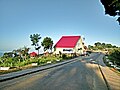 A resort at Sajek union, Rangamati
 Statue of sitting Buddha, Rangamati
 Shubhalang waterfall
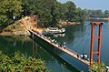 The Hanging Bridge
 Lake surrounded by hills during winter
 Sun Rays Through The Clouds
 Fishing boat of the Rangamati locals
 Local People using boats for transportation
 Kaptai Lake view


See also
Notes
- Rangamati, Chandragona, Barkal and Langadu thanas of Chittagong Hill Tracts district
- 'Tribal' was used as a blanket term for religious traditions of all tribes, and many of these tribes followed a more mainstream religion.
- Including Jainism, Zoroastrianism, Judaism, Ad-Dharmis, or not stated
