Redstone, Montana
From Wikipedia, the free encyclopedia
Redstone, Montana | |
|---|---|
 Redstone, Montana  Redstone, Montana | |
| Coordinates: 48°49′18″N 104°56′36″W / 48.82167°N 104.94333°W | |
| Country | United States |
| State | Montana |
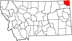
| County | Sheridan |
| Area | |
• Total | 0.34 sq mi (0.87 km2) |
| • Land | 0.34 sq mi (0.87 km2) |
| • Water | 0 sq mi (0.00 km2) |
| Elevation | 2,103 ft (641 m) |
| Population (2020) | |
• Total | 13 |
| • Density | 38.7/sq mi (14.93/km2) |
| Time zone | UTC-7 (Mountain (MST)) |
| • Summer (DST) | UTC-6 (MDT) |
| ZIP code | 59257 |
| Area code | 406 |
| GNIS feature ID | 2806665[2] |
Redstone is an unincorporated community in Sheridan County, Montana, United States. As of the 2020 census, Redstone had a population of 13.[3] Redstone is located on Montana Highway 5, 18 miles (29 km) west of Plentywood. The community had a post office from 1903[4] until March 9, 2013; it still has its own ZIP code, 59257.[5][6]
It is near the confluence of the Muddy River and Eagle Creek.
| Climate data for Redstone, Montana, 1991–2020 normals, 1951-2020 extremes: 2106ft (642m) | |||||||||||||
|---|---|---|---|---|---|---|---|---|---|---|---|---|---|
| Month | Jan | Feb | Mar | Apr | May | Jun | Jul | Aug | Sep | Oct | Nov | Dec | Year |
| Record high °F (°C) | 62 (17) |
68 (20) |
79 (26) |
92 (33) |
102 (39) |
105 (41) |
110 (43) |
110 (43) |
104 (40) |
96 (36) |
80 (27) |
60 (16) |
110 (43) |
| Mean maximum °F (°C) | 47.9 (8.8) |
49.6 (9.8) |
64.7 (18.2) |
79.1 (26.2) |
88.2 (31.2) |
93.5 (34.2) |
97.9 (36.6) |
98.3 (36.8) |
91.4 (33.0) |
79.9 (26.6) |
61.1 (16.2) |
47.3 (8.5) |
100.5 (38.1) |
| Mean daily maximum °F (°C) | 23.7 (−4.6) |
26.3 (−3.2) |
39.1 (3.9) |
55.6 (13.1) |
67.0 (19.4) |
75.1 (23.9) |
82.4 (28.0) |
82.3 (27.9) |
71.8 (22.1) |
54.9 (12.7) |
37.8 (3.2) |
25.6 (−3.6) |
53.5 (11.9) |
| Daily mean °F (°C) | 11.2 (−11.6) |
15.1 (−9.4) |
27.1 (−2.7) |
40.7 (4.8) |
52.0 (11.1) |
60.9 (16.1) |
66.7 (19.3) |
65.5 (18.6) |
55.1 (12.8) |
41.2 (5.1) |
26.0 (−3.3) |
14.4 (−9.8) |
39.7 (4.3) |
| Mean daily minimum °F (°C) | −1.3 (−18.5) |
3.8 (−15.7) |
15.2 (−9.3) |
25.9 (−3.4) |
36.9 (2.7) |
46.8 (8.2) |
51.0 (10.6) |
48.7 (9.3) |
38.4 (3.6) |
27.4 (−2.6) |
14.2 (−9.9) |
3.2 (−16.0) |
25.8 (−3.4) |
| Mean minimum °F (°C) | −30.2 (−34.6) |
−22.8 (−30.4) |
−10.1 (−23.4) |
9.7 (−12.4) |
21.3 (−5.9) |
33.3 (0.7) |
38.5 (3.6) |
34.3 (1.3) |
20.3 (−6.5) |
6.9 (−13.9) |
−9.2 (−22.9) |
−25.4 (−31.9) |
−35.6 (−37.6) |
| Record low °F (°C) | −53 (−47) |
−48 (−44) |
−35 (−37) |
−27 (−33) |
5 (−15) |
23 (−5) |
29 (−2) |
16 (−9) |
9 (−13) |
−12 (−24) |
−32 (−36) |
−52 (−47) |
−53 (−47) |
| Average precipitation inches (mm) | 0.42 (11) |
0.24 (6.1) |
0.67 (17) |
0.86 (22) |
2.22 (56) |
3.08 (78) |
2.14 (54) |
1.80 (46) |
0.97 (25) |
0.88 (22) |
0.43 (11) |
0.57 (14) |
14.28 (362.1) |
| Average snowfall inches (cm) | 4.6 (12) |
2.7 (6.9) |
2.1 (5.3) |
0.8 (2.0) |
0.3 (0.76) |
0.0 (0.0) |
0.0 (0.0) |
0.0 (0.0) |
0.0 (0.0) |
0.7 (1.8) |
3.6 (9.1) |
3.1 (7.9) |
17.9 (45.76) |
| Source 1: NOAA (1981-2010 snowfall)[7][8] | |||||||||||||
| Source 2: XMACIS (temp records & monthly max/mins)[9] | |||||||||||||