Rubio, Iowa
From Wikipedia, the free encyclopedia
Rubio, Iowa | |
|---|---|
 Rubio Community Building | |
 Interactive map of Rubio, Iowa | |
| Coordinates: 41°13′16″N 91°56′15″W / 41.22111°N 91.93750°W[1] | |
| Country | |
| State | |
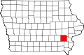
| County | Washington County |
| Established | 1900 |
| Elevation | 640 ft (200 m) |
| Time zone | UTC-6 (Central (CST)) |
| • Summer (DST) | UTC-5 (CDT) |
| GNIS feature ID | 460841[1] |
Rubio is an unincorporated community in southwest Washington County, Iowa, United States. It is located on County Highway G67 approximately three miles northeast of Richland in adjacent Keokuk, County. The Skunk River flows past the north side of the community.[2][3]