Sandfirden
Village in Friesland, Netherlands
From Wikipedia, the free encyclopedia
Sandfirden (West Frisian: Sânfurd) is a small village in Súdwest-Fryslân municipality in the province of Friesland, the Netherlands. It had a population of around 25 in January 2017.[3]

Sandfirden
Sânfurd | |
|---|---|
Village | |
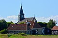
Sandfirden in 2015 | |
 Location in the former Wymbritseradiel municipality | |
 Sandfirden Location in the Netherlands  Sandfirden Sandfirden (Netherlands) | |
| Country | |
| Province | |
| Municipality | |
| Area | |
• Total | 3.17 km2 (1.22 sq mi) |
| Elevation | 0.0 m (0 ft) |
| Population (2021)[1] | |
• Total | 30 |
| • Density | 9.5/km2 (25/sq mi) |
| Time zone | UTC+1 (CET) |
| • Summer (DST) | UTC+2 (CEST) |
| Postal code | 8613[1] |
| Dialing code | 0515 |
History
The village was first mentioned in 1245 as Sandforde, and means sand and fordable place.[4] Sandfirden is a little terp (artificial living mound) village which developed during the Middle Ages around lakes. It used to be accessible only by water.[5] Sandfirden consists of only one street without a name.[6]
In 1399, funds were provided by Albert I, Duke of Bavaria to build a church.[6] The church was replaced in 1732.[5] The tower was struck by lightning and damaged in 1970. Nowadays, the church is in use for weddings, concerts and parties.[6]
Sandfirden was home to 52 people in 1840. During World War II, the village was home to many onderduikers (people in hiding). One farm was burnt down after a weapons stash had been discovered by the Germans. Before 2011, the village was part of the Wymbritseradiel municipality.[6]
Gallery
 Church of Sandfirden
