Sasbachwalden
From Wikipedia, the free encyclopedia
Sasbachwalden | |
|---|---|
 Coat of arms | |
Location of Sasbachwalden within Ortenaukreis district 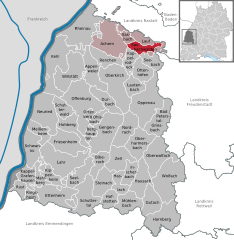 | |
 Sasbachwalden  Sasbachwalden | |
| Coordinates: 48°37′06″N 08°07′38″E / 48.61833°N 8.12722°E | |
| Country | Germany |
| State | Baden-Württemberg |
| Admin. region | Freiburg |
| District | Ortenaukreis |
| Government | |
| • Mayor (2024–32) | Sonja Schuchter[1] (CDU) |
| Area | |
• Total | 18.13 km2 (7.00 sq mi) |
| Elevation | 257 m (843 ft) |
| Population (2022-12-31)[2] | |
• Total | 2,604 |
| • Density | 140/km2 (370/sq mi) |
| Time zone | UTC+01:00 (CET) |
| • Summer (DST) | UTC+02:00 (CEST) |
| Postal codes | 77887 |
| Dialling codes | 07841 |
| Vehicle registration | OG, BH, KEL, LR, WOL |
| Website | www.sasbachwalden.de |
Sasbachwalden is a Black Forest municipality in Western Baden-Württemberg, Germany, popular with tourists. It is located on the western slopes of mountain Hornisgrinde in the Northern Black Forest and belongs to the district of Ortenau. More than 70% of the town area are forest.
Sasbachwalden was first mentioned in 1347 as a group of individual farms and houses. Only in 1817 Sasbachwalden became an independent community. Since 1973 the town belongs to district of Ortenau.
