Sassenburg
From Wikipedia, the free encyclopedia
Sassenburg | |
|---|---|
 Coat of arms | |
Location of Sassenburg within Gifhorn district  | |
 Sassenburg  Sassenburg | |
| Coordinates: 52°31′N 10°38′E / 52.517°N 10.633°E | |
| Country | Germany |
| State | Lower Saxony |
| District | Gifhorn |
| Subdivisions | 6 districts |
| Government | |
| • Mayor (2021–26) | Jochen Koslowski[1] (Ind.) |
| Area | |
• Total | 88.4 km2 (34.1 sq mi) |
| Highest elevation | 69 m (226 ft) |
| Lowest elevation | 55 m (180 ft) |
| Population (2022-12-31)[2] | |
• Total | 12,092 |
| • Density | 140/km2 (350/sq mi) |
| Time zone | UTC+01:00 (CET) |
| • Summer (DST) | UTC+02:00 (CEST) |
| Postal codes | 38524 |
| Dialling codes | 05371, 05378, 05379 |
| Vehicle registration | GF |
| Website | www.sassenburg.de |
Sassenburg is a municipality in the district of Gifhorn, Lower Saxony, Germany. It is situated approximately 7 km northeast of Gifhorn, and 15 km northwest of Wolfsburg. Sassenburg includes the villages of Dannenbüttel, Grußendorf, Neudorf-Platendorf, Stüde, Triangel and Westerbeck. The seat of the municipality is in the village Westerbeck.
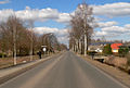 The main street in Neudorf-Platendorf
 The Lutheran church in Neudorf-Platendorf
 Lake Bernsteinsee near Stüde
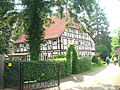 House in Triangel

_IMG_5849.jpg)


