Schrecksbach
From Wikipedia, the free encyclopedia
Schrecksbach | |
|---|---|
 Coat of arms | |
Location of Schrecksbach
within Schwalm-Eder-Kreis district 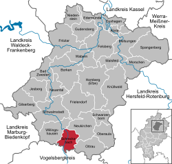 | |
 Location of Schrecksbach | |
 Schrecksbach  Schrecksbach | |
| Coordinates: 50°50′N 9°17′E / 50.833°N 9.283°E | |
| Country | Germany |
| State | Hesse |
| Admin. region | Kassel |
| District | Schwalm-Eder-Kreis |
| Government | |
| • Mayor (2023–29) | Daniel Helwig[1] (SPD) |
| Area | |
• Total | 36.61 km2 (14.14 sq mi) |
| Elevation | 280 m (920 ft) |
| Population (2023-12-31)[2] | |
• Total | 2,948 |
| • Density | 80.52/km2 (208.6/sq mi) |
| Time zone | UTC+01:00 (CET) |
| • Summer (DST) | UTC+02:00 (CEST) |
| Postal codes | 34637 |
| Dialling codes | 06698 |
| Vehicle registration | HR |
| Website | www.schrecksbach.de |
Schrecksbach is a municipality in the Schwalm-Eder district in Hesse State, Germany.
Location
Schrecksbach lies in the southern part of Schwalm-Eder on the River Schwalm, and forms the border with the Vogelsbergkreis.
Constituent communities
The following centres belong to the greater community:
- Hof Röllhausen
- Holzburg
- Röllshausen
- Salmshausen
- Schönberg
- Schrecksbach
- Trockenbach
History
Schrecksbach is a very old place that was mentioned in one of Charlemagne's documents as "Screggesbaha am Sualmanahafluß" as early as 782.
The community itself was first mentioned in 1223.
On 31 October 1806, Napoleon's army overran the country. Elector William I fled and was unseated. At this time, Schrecksbach was occupied by enemy (ie French) troops, suffering heavily as a result.
