Schwarzenbach am Wald
Town in Bavaria, Germany
From Wikipedia, the free encyclopedia
Schwarzenbach am Wald (German pronunciation: [ˈʃvaʁtsn̩bax ʔam ˈvalt] ⓘ, lit. 'Schwarzenbach on the Forest') is a town in the district of Hof, in Bavaria, Germany. It is situated 21 km west of Hof, and 23 km northeast of Kulmbach.

Schwarzenbach a.Wald | |
|---|---|
Lutheran Church of Jesus | |
 Coat of arms | |
Location of Schwarzenbach a.Wald
within Hof district 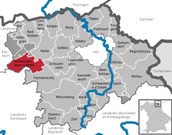 | |
 Location of Schwarzenbach a.Wald | |
 Schwarzenbach a.Wald  Schwarzenbach a.Wald | |
| Coordinates: 50°17′0″N 11°37′15″E | |
| Country | Germany |
| State | Bavaria |
| Admin. region | Oberfranken |
| District | Hof |
| Subdivisions | 39 Ortsteile |
| Government | |
| • Mayor (2018–24) | Reiner Feulner[1] (CSU) |
| Area | |
• Total | 36.7 km2 (14.2 sq mi) |
| Elevation | 686 m (2,251 ft) |
| Population (2024-12-31)[2] | |
• Total | 4,231 |
| • Density | 115/km2 (299/sq mi) |
| Time zone | UTC+01:00 (CET) |
| • Summer (DST) | UTC+02:00 (CEST) |
| Postal codes | 95131 |
| Dialling codes | 09289 |
| Vehicle registration | HO |
| Website | www.schwarzenbach-wald.de |
Geography
Geographical situation
Schwarzenbach am Wald is situated in a natural environment at the bottom of the Döbraberg in the Frankenwald natural park.
City structure
- Äußera
- Bernstein am Wald
- Breitengrund
- Döbra
- Dorschenmühle
- Gemeinreuth
- Göhren
- Gottsmannsgrün
- Grubenberg
- Kleindöbra
- Lerchenhügel
- Löhmar
- Löhmarmühle
- Meierhof
- Oberleupoldsberg
- Pillmersreuth
- Poppengrün
- Poppengrund
- Räumlas
- Räumlasmühle
- Rauschenhammermühle
- Rodeck
- Sängerwald
- Schlag
- Schönbrunn
- Schönwald
- Schmölz
- Schübelhammer
- Schwarzenstein
- Sorg
- Straßdorf
- Straßhaus
- Süßengut
- Thiemitz
- Thron
- Überkehr
- Unterleupoldsberg
- Viceburg
- Zuckmantel