Seneca Knolls, New York
From Wikipedia, the free encyclopedia
Seneca Knolls, New York | |
|---|---|
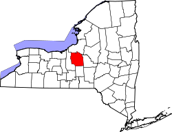
 Location in Onondaga County and the state of New York. | |
| Coordinates: 43°7′20″N 76°17′2″W / 43.12222°N 76.28389°W | |
| Country | United States |
| State | New York |
| County | Onondaga |
| Area | |
• Total | 1.27 sq mi (3.28 km2) |
| • Land | 1.27 sq mi (3.28 km2) |
| • Water | 0 sq mi (0.00 km2) |
| Elevation | 407 ft (124 m) |
| Population (2020) | |
• Total | 1,992 |
| • Density | 1,572/sq mi (606.8/km2) |
| Time zone | UTC-5 (Eastern (EST)) |
| • Summer (DST) | UTC-4 (EDT) |
| FIPS code | 36-66366 |
| GNIS feature ID | 1852911 |
Seneca Knolls is a hamlet (and census-designated place) in Onondaga County, New York, United States. As of the 2020 census, Seneca Knolls had a population of 1,992.[2]
Seneca Knolls is in the eastern part of the town of Van Buren.
Seneca Knolls is located at 43°7′20″N 76°17′2″W / 43.12222°N 76.28389°W (43.122117, -76.283878).[3]
According to the United States Census Bureau, the CDP has a total area of 1.2 square miles (3.1 km2), all land.
The community lies mostly between Interstate 690 and New York State Route 48 and is northwest of Onondaga Lake.