
Seybothenreuth
Municipality in Bavaria, Germany
From Wikipedia, the free encyclopedia
Seybothenreuth is a municipality in the district of Bayreuth in Upper Franconia in Bavaria, Germany.

Seybothenreuth | |
|---|---|
|
Coat of arms | |
Location of Seybothenreuth
within Bayreuth district 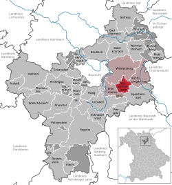 | |
 Location of Seybothenreuth | |
  Seybothenreuth  Seybothenreuth | |
| Coordinates: 49°53′39″N 11°42′18″E | |
| Country | Germany |
| State | Bavaria |
| Admin. region | Oberfranken |
| District | Bayreuth |
| Municipal assoc. | Weidenberg |
| Subdivisions | 9 Ortsteile |
| Government | |
| • Mayor (2020–26) | Reinhard Preißinger[1] |
| Area | |
• Total | 17.44 km2 (6.73 sq mi) |
| Elevation | 420 m (1,380 ft) |
| Population (2024-12-31)[2] | |
• Total | 1,279 |
| • Density | 73.34/km2 (189.9/sq mi) |
| Time zone | UTC+01:00 (CET) |
| • Summer (DST) | UTC+02:00 (CEST) |
| Postal codes | 95517 |
| Dialling codes | 09275, 09278 |
| Vehicle registration | BT |
| Website | www.seybothenreuth.de |
