Simms Island
From Wikipedia, the free encyclopedia
 The former location of Simms Island in March 2023. | |
 Simms Island  Simms Island  Simms Island | |
| Geography | |
|---|---|
| Location | Northern California |
| Coordinates | 37°57′33″N 122°30′18″W / 37.95917°N 122.50500°W[1] |
| Adjacent to | San Francisco Bay |
| Highest elevation | 13 ft (4 m)[1] |
| Administration | |
United States | |
| State | |
| County | Marin |
Simms Island is a former marsh island in San Francisco Bay.[2] It is in Marin County, California; Its coordinates are 37°57′33″N 122°30′18″W / 37.95917°N 122.50500°W[1], and the United States Geological Survey (USGS) gave its elevation as 13 ft (4.0 m) in 1981.[1] It appears as an island on a USGS map in 1897;[3] it is labeled in a 1954 map, but fully connected to the mainland.[4]
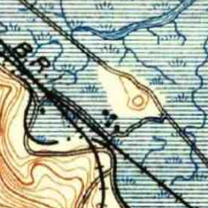 USGS survey map from 1897.
 USGS survey map from 1954.
 USGS aerial imagery from 2021.


