Sluipwijk
Village in South Holland, Netherlands
From Wikipedia, the free encyclopedia
Sluipwijk is a village in the Dutch province of South Holland. It is a part of the former municipality of Reeuwijk, and lies about 3 km northeast of Gouda. The villages is surrounded by the lakes of the Reeuwijkse Plassen.

Sluipwijk | |
|---|---|
Village | |
Farm in Sluipwijk | |
 Sluipwijk Location in the province of South Holland in the Netherlands  Sluipwijk Location in the Netherlands | |
| Coordinates: 52°02′19″N 4°44′31″E | |
| Country | Netherlands |
| Province | South Holland |
| Municipality | Bodegraven-Reeuwijk |
| Area | |
• Total | 5.02 km2 (1.94 sq mi) |
| Population (2021)[1] | |
• Total | 405 |
| • Density | 80.7/km2 (209/sq mi) |
| Time zone | UTC+1 (CET) |
| • Summer (DST) | UTC+2 (CEST) |
| Postal code | 2811[1] |
| Dialing code | 0182 |
The village was first mentioned between 1280 and 1287 as slupewiic. The etymology is unclear.[2] Sluipwijk is a linear settlement inside the Reeuwijkse Plassen, a lake area which developed as a result of the peat excavation in the area.[3]
Sluipwijk was a separate municipality until 1870, when it became part of Reeuwijk. In 1821, Wiltenburg had been added to Sluipwijk.[4]
Gallery
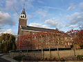 Dutch Reformed church
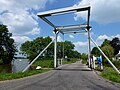 Draw bridge
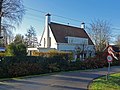 House in Sluipwijk
_Kerk_met_begraafplaats.JPG)

