Soil in Dogu'a Tembien
From Wikipedia, the free encyclopedia

| Soil in Dogu'a Tembien | |
|---|---|
| Stratigraphic range: Holocene | |
_Thapto_Haplic_Leptosol_at_Mere'a_Ziban_Ethiopia.jpg) Mazi-Pellic Vertisol in the Hagere Selam Highlands | |
| Type | Soilscape |
| Thickness | 2 m (6.6 ft) |
| Lithology | |
| Primary | Clay, Loam |
| Other | Sand, Rocks |
| Location | |
| Coordinates | 13°30′N 39°10′E / 13.5°N 39.16°E / 13.5; 39.16 |
| Region | Tigray |
| Country |  Ethiopia Ethiopia |
| Extent | Dogu'a Tembien |
  Soil in Dogu'a Tembien (Ethiopia) | |
The soils of the Dogu'a Tembien woreda (district) in Tigray (Ethiopia) reflect its longstanding agricultural history, highly seasonal rainfall regime, relatively low temperatures, an extremely great variety in lithology (with dominance of basalts and limestone) and steep slopes. Outstanding features in the soilscape are the fertile highland Vertisols and Phaeozems in forests.[1][2][3][4][5]
Climate
Annual rainfall depth is very variable with an average of around 800 mm.[6] Most rains fall during the main rainy season, which typically extends from June to September. Mean temperature in woreda town Hagere Selam is 16.8 °C, oscillating between average daily minimum of 9.3 °C and maximum of 24.1 °C. The contrasts between day and night air temperatures are much larger than seasonal contrasts.[7]
Geology
From the higher to the lower locations, the following geological formations are present:[8]
- Phonolite plugs
- Upper basalt
- Interbedded lacustrine deposits
- Lower basalt
- Amba Aradam Formation
- Agula Shale[9]
- Mekelle Dolerite[10]
- Antalo Limestone
- Adigrat Sandstone
- Enticho Sandstone
- Edaga Arbi Glacials
- Quaternary alluvium and freshwater tufa[11]
Topography
As part of the Ethiopian Highlands the land has undergone a rapid tectonic uplift, leading the occurrence of mountain peaks, plateaus, valleys and gorges.
Land use
Generally speaking the level lands and intermediate slopes are occupied by cropland, while there is rangeland and shrubs on the steeper slopes. Remnant forests occur around Orthodox Christian churches and a few inaccessible places. A recent trend is the widespread planting of eucalyptus trees.
Environmental changes
Soil degradation in this district became important when humans started deforestation almost 5000 years ago.[12][13] Depending on land use history, locations have been exposed in varying degrees to such land degradation.
Geomorphic regions and soil units
Given the complex geology and topography of the district, it has been organised into land systems - areas with specific and unique geomorphic and geological characteristics, characterised by a particular soil distribution along the soil catena.[14][15][16] Soil types are classified in line with World Reference Base for Soil Resources and reference made to main characteristics that can be observed in the field.
Hagere Selam Highlands


This land system occurs on the central basalt plateau and adjacent ridges; Hagere Selam is entirely in this land system, which is also predominant in tabias Selam, Mahbere Sillasie, Melfa, Lim'at, Seret, Simret, Mika'el Abiy as well as Arebay.
- Associated soil types
- Inclusions
- Rock outcrops and very shallow soils (Lithic Leptosol) (1)
- Rock outcrops and very shallow soils on limestone (Calcaric Leptosol) (2)
- Moderately deep, stony, dark cracking clays on calcaric material (Calcaric Vertic Cambisol) (17)
- Deep dark cracking clays with very good natural fertility, waterlogged during the wet season (Chromic Vertisol, Pellic Vertisol) (12)
- Shallow stony dark loams on calcaric material (Calcaric Regosol, Calcaric Cambisol) (22)
- Brown loamy soils on basalt with good natural fertility (Luvisol) (26)
Gallery: soil profiles in the Hagere Selam Highlands
 Mazi-Pellic Vertisol (Eutric) Thapto Haplic Leptosol at Mere'a Ziban
 Humi-Cumuliskeletic Regosol in Kuliheni (Harena)
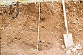 Humi-Cumulicalcaric Regosol in May Addi Abagie (Harena)
 Calcaric Regosol in Luqmuts rangeland (Hech'i)
 Luvic Phaeozem in Luqmuts forest (Hech'i)


Basalt plateau


This land system occurs on the westernmost ridges of Dogu'a Tembien, where basalt is overlying Adigrat Sandstone without intervening Antalo Limestone; it is predominant in tabias Menachek, Mizan, Aregen and Degol Woyane.
- Associated soil types
- Inclusions
Adigrat Sandstone cliff and footslope


This land system occurs on the steep slopes towards the southwestern lowlands; it occupies large areas of tabias Walta, Simret, Mizan, Aregen, Degol Woyane, Mahbere Sillasie and Haddinnet.
- Associated soil types
- Inclusions
- shallow, dry soils with very high amounts of stones (Leptic and Skeletic Cambisol and Regosol) (4)
- deep, dark cracking clays with good fertility, but problems of waterlogging (Chromic and Pellic Vertisol) (12)
- soils with stagnating water due to an abrupt textural change such as sand over clay (Haplic Planosol]]) (34)
Alluvial plain of Giba River


This land system occurs in Kemishana at the southwestern side of Dogu'a Tembien, where the Giba River gorge widens up when entering into the Abergele lowlands.
- Associated soil types
- deep dark cracking clays with very good natural fertility, waterlogged during the wet season (Chromic Vertisol, Pellic Vertisol) (12)
- brown loamy sands developed on alluvium along Giba River (Fluvisol) (30)
Strongly incised Giba gorge


This land system occurs on in the deeply incised gorge of Giba River, at the lower side of tabias Walta, Inda Sillasie, Amanit and Debre Nazret.
- Dominant soil type: complex of rock outcrops, very stony and very shallow soils ((Lithic) Leptosol) (1)
- Associated soil types
Gently rolling Antalo Limestone plateau, holding cliffs and valley bottoms


This land system occurs on Antalo Limestone, it is predominant in tabias Walta, Inda Sillasie, Ayninbirkekin, Amanit and Debre Nazret.
- Associated soil types
- Inclusions
- Rock outcrops and very shallow soils (Lithic Leptosol) (1)
- Shallow very stony loamy soil on limestone (Skeletic Calcaric Cambisol) (5)
- Deep dark cracking clays with very good natural fertility, waterlogged during the wet season (Chromic Vertisol, Pellic Vertisol) (12)
- Brown to dark sands and silt loams on alluvium (Vertic Fluvisol, Eutric Fluvisol, Haplic Fluvisol) (30)
Gently undulating Agula shale plateau with dolerite

.jpg)
This land system occurs on Agula Shale at the east of Dogu'a Tembien, it is predominant in tabias Addi Azmera, Mizane Birhan and parts of Debre Nazret, Haddinnet and Addilal.
- Dominant soil type: stony, dark cracking clays with good natural fertility (Vertic Cambisol) (10)
- Associated soil types
- Inclusions
Incised Giba plateau, upstream of (future) Lake Giba


This land system occurs on Antalo Limestone; it is predominant in tabias Emni Ankelalu and Addilal.
- Associated soil types
- Inclusions
- Shallow, stony loam soils with moderate fertility (Eutric Regosol and Cambisol) (21)
- Deep, dark cracking clays with good fertility, but problems of waterlogging (Chromic and Pellic Vertisol) (12)
- Brown to dark, silty clay loams to loamy sands developed on alluvium, with good natural fertility (Fluvisol) (30)
Giba wide valley bottom


This land system occurs where the Giba valley widens; it occurs only at the lower places of tabia Emni Ankelalu and will be flooded once the Lake Giba reservoir will be filled.
- Associated soil types
- Inclusions
Soil erosion and conservation
The reduced soil protection by vegetation cover, combined with steep slopes and erosive rainfall has led to excessive soil erosion.[12][17][18] Nutrients and organic matter were lost and soil depth was reduced. Hence, soil erosion is an important problem, which results in low crop yields and biomass production.[19][20] As a response to the strong degradation and thanks to the hard labour of many people in the villages, soil conservation has been carried out on a large scale since the 1980s and especially 1980s; this has curbed rates of soil loss.[21][22]
Measures include the construction of infiltration trenches, stone bunds,[23] check dams,[24] small reservoirs such as Chini and May Leiba as well as a major biological measure: exclosures in order to allow forest regeneration.[3] On the other hand, it remains difficult to convince farmers to carry out measures within the farmland (in situ soil management), such as bed and furrows or zero grazing, as there is a fear for loss of income from the land. Such techniques are however very effective.[25]
References
- ↑ Nyssen, Jan; Tielens, Sander; Gebreyohannes, Tesfamichael; Araya, Tigist; Teka, Kassa; Van De Wauw, Johan; Degeyndt, Karen; Descheemaeker, Katrien; Amare, Kassa; Haile, Mitiku; Zenebe, Amanuel; Munro, Neil; Walraevens, Kristine; Gebrehiwot, Kindeya; Poesen, Jean; Frankl, Amaury; Tsegay, Alemtsehay; Deckers, Jozef (2019). "Understanding spatial patterns of soils for sustainable agriculture in northern Ethiopia's tropical mountains". PLOS ONE. 14 (10) e0224041. Bibcode:2019PLoSO..1424041N. doi:10.1371/journal.pone.0224041. PMC 6804989. PMID 31639144.
- ↑ Nyssen, J.; Naudts, J.; De Geyndt, K.; Haile, Mitiku; Poesen, J.; Moeyersons, J.; Deckers, J. (2008). "Soils and land use in the Tigray highlands (Northern Ethiopia)". Palaeogeography, Palaeoclimatology, Palaeoecology. 19 (3): 257–274. doi:10.1002/ldr.840. S2CID 128492271.
- 1 2 Descheemaeker, K. and colleagues (2006). "Sediment deposition and pedogenesis in exclosures in the Tigray Highlands, Ethiopia". Geoderma. 132 (3–4): 291–314. Bibcode:2006Geode.132..291D. doi:10.1016/j.geoderma.2005.04.027.
- ↑ Van de Wauw, J. and colleagues (2008). "Soil-landscape relationships in the basalt-dominated highlands of Tigay, Ethiopia". Catena. 75: 117–127. doi:10.1016/j.catena.2008.04.006.
- ↑ Hunting Technical Services. Central Tigre Development Study – Tigre Province Ethiopia, Working Paper I: Soils and land classification. Hemel Hempstead (U.K.): Hunting Technical Services Ltd.
- ↑ Jacob, M. and colleagues (2013). "Assessing spatio-temporal rainfall variability in a tropical mountain area (Ethiopia) using NOAAs Rainfall Estimates". International Journal of Remote Sensing. 34 (23): 8305–8321. Bibcode:2013IJRS...34.8319J. doi:10.1080/01431161.2013.837230. hdl:1854/LU-4252226. S2CID 140560276.
- ↑ Jacob, M. and colleagues (2019). Dogu'a Tembien's Tropical Mountain Climate. In: Geo-trekking in Ethiopia's Tropical Mountains — The Dogu'a Tembien District. SpringerNature. doi:10.1007/978-3-030-04955-3_3. ISBN 978-3-030-04954-6. S2CID 199105560.
- ↑ Sembroni, A.; Molin, P.; Dramis, F. (2019). Regional geology of the Dogu'a Tembien massif. In: Geo-trekking in Ethiopia's Tropical Mountains — The Dogu'a Tembien District. SpringerNature. ISBN 978-3-030-04954-6.
- ↑ Bosellini, A.; Russo, A.; Fantozzi, P.; Assefa, G.; Tadesse, S. (1997). "The Mesozoic succession of the Mekelle Outlier (Tigrai Province, Ethiopia)". Mem. Sci. Geol. 49: 95–116.
- ↑ Tefera, M.; Chernet, T.; Haro, W. Geological Map of Ethiopia (1:2,000,000). Addis Ababa, Ethiopia: Ethiopian Institute of Geological Survey.
- ↑ Moeyersons, J. and colleagues (2006). "Age and backfill/overfill stratigraphy of two tufa dams, Tigray Highlands, Ethiopia: Evidence for Late Pleistocene and Holocene wet conditions". Palaeogeography, Palaeoclimatology, Palaeoecology. 230 (1–2): 162–178. Bibcode:2006PPP...230..165M. doi:10.1016/j.palaeo.2005.07.013.
- 1 2 Nyssen, Jan; Poesen, Jean; Moeyersons, Jan; Deckers, Jozef; Haile, Mitiku; Lang, Andreas (2004). "Human impact on the environment in the Ethiopian and Eritrean highlands - a state of the art". Earth-Science Reviews. 64 (3–4): 273–320. Bibcode:2004ESRv...64..273N. doi:10.1016/S0012-8252(03)00078-3.
- ↑ Blond, N. and colleagues (2018). "Terrasses alluviales et terrasses agricoles. Première approche des comblements sédimentaires et de leurs aménagements agricoles depuis 5000 av. n. è. à Wakarida (Éthiopie)" (PDF). Géomorphologie: Relief, Processus, Environnement. 24 (3): 277–300. doi:10.4000/geomorphologie.12258. S2CID 134513245.
- ↑ Bui, E.N. (2004). "Soil survey as a knowledge system". Geoderma. 120 (1–2): 17–26. Bibcode:2004Geode.120...17B. doi:10.1016/j.geoderma.2003.07.006.
- ↑ "Principes de la cartographie des pédopaysages dans les Alpes". Écologie. 29 (1–2): 49. 1998. ProQuest 223074690.
- ↑ Tielens, Sander (2012). Towards a soil map of the Geba catchment using benchmark soils. MSc thesis. Leuven, Belgium: K.U.Leuven.
- ↑ Demel Teketay (2001). "Deforestation, wood famine, and environmental degradation in Ethiopia's highland ecosystems: urgent need for action". Northeast African Studies. 8 (1): 53–76. doi:10.1353/nas.2005.0020. JSTOR 41931355. S2CID 145550500.
- ↑ Nyssen, Jan; Frankl, Amaury; Zenebe, Amanuel; Deckers, Jozef; Poesen, Jean (2015). "Land management in the northern Ethiopian highlands: local and global perspectives; past, present and future". Land Degradation & Development. 26 (7): 759–794. doi:10.1002/ldr.2336. S2CID 129501591.
- ↑ Vancampenhout, K. and colleagues (2019). Sheet and Rill Erosion and Its Control: Lessons from Dogu'a Tembien. In: Geo-trekking in Ethiopia's Tropical Mountains — The Dogu'a Tembien District. SpringerNature. doi:10.1007/978-3-030-04955-3_21. ISBN 978-3-030-04954-6. S2CID 199110301.
- ↑ Frankl, A. and colleagues (2019). Gully Erosion and Control in the Tembien Highlands. In: Geo-trekking in Ethiopia's Tropical Mountains — The Dogu'a Tembien District. SpringerNature. doi:10.1007/978-3-030-04955-3_22. ISBN 978-3-030-04954-6. S2CID 199099185.
- ↑ Farmland Management, Tillage and Resulting Cultivation Terraces. In: Geo-trekking in Ethiopia's Tropical Mountains — The Dogu'a Tembien District. SpringerNature. 2019. doi:10.1007/978-3-030-04955-3_26. ISBN 978-3-030-04954-6. S2CID 199097368.
- ↑ Reubens, B. and colleagues (2019). Research-Based Development Projects in Dogu'a Tembien. In: Geo-trekking in Ethiopia's Tropical Mountains — The Dogu'a Tembien District. SpringerNature. doi:10.1007/978-3-030-04955-3_30. ISBN 978-3-030-04954-6. S2CID 199261393.
- ↑ Nyssen, Jan; Poesen, Jean; Gebremichael, Desta; Vancampenhout, Karen; d'Aes, Margo; Yihdego, Gebremedhin; Govers, Gerard; Leirs, Herwig; Moeyersons, Jan; Naudts, Jozef; Haregeweyn, Nigussie; Haile, Mitiku; Deckers, Jozef (2007). "Interdisciplinary on-site evaluation of stone bunds to control soil erosion on cropland in Northern Ethiopia". Soil and Tillage Research. 94 (1): 151–163. doi:10.1016/j.still.2006.07.011. hdl:1854/LU-378900.
- ↑ Nyssen, J.; Veyret-Picot, M.; Poesen, J.; Moeyersons, J.; Haile, Mitiku; Deckers, J.; Govers, G. (2004). "The effectiveness of loose rock check dams for gully control in Tigray, Northern Ethiopia". Soil Use and Management. 20: 55–64. doi:10.1111/j.1475-2743.2004.tb00337.x. S2CID 98547102.
- ↑ Tewodros Gebreegziabher, and colleagues (2009). "Contour furrows for in situ soil and water conservation, Tigray, Northern Ethiopia". Soil and Tillage Research. 103 (2): 257–264. doi:10.1016/j.still.2008.05.021.