South Uniontown, Pennsylvania
From Wikipedia, the free encyclopedia
South Uniontown, Pennsylvania | |
|---|---|
  South Uniontown  South Uniontown | |
| Coordinates: 39°53′38″N 79°44′48″W / 39.89389°N 79.74667°W | |
| Country | United States |
| State | Pennsylvania |
| County | Fayette |
| Township | South Union |
| Area | |
• Total | 0.46 sq mi (1.2 km2) |
| • Land | 0.46 sq mi (1.2 km2) |
| • Water | 0 sq mi (0.0 km2) |
| Elevation | 1,076 ft (328 m) |
| Population (2010) | |
• Total | 1,360 |
| • Density | 2,991/sq mi (1,154.7/km2) |
| Time zone | UTC-5 (Eastern (EST)) |
| • Summer (DST) | UTC-4 (EDT) |
| ZIP code | 15401[1] |
| Area code | 724 |
| FIPS code | 42-72552 |
| GNIS feature ID | 2633311 |
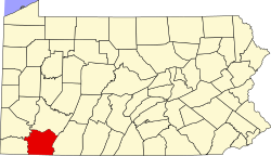
South Uniontown is a census-designated place in South Union Township, Pennsylvania, United States. As of the 2010 census, the population was 1,360.[2]
The community borders the southwestern side of the city of Uniontown, the Fayette County seat. U.S. routes 40 and 119, a four-lane bypass of the city and in this area part of the Mon–Fayette Expressway, form the western edge of the CDP.