Starkenberg
From Wikipedia, the free encyclopedia
Starkenberg | |
|---|---|
 Coat of arms | |
Location of Starkenberg within Altenburger Land district 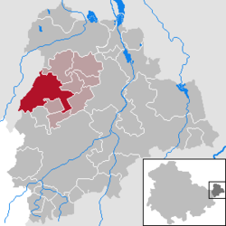 | |
 Starkenberg  Starkenberg | |
| Coordinates: 50°59′5″N 12°18′45″E / 50.98472°N 12.31250°E | |
| Country | Germany |
| State | Thuringia |
| District | Altenburger Land |
| Municipal assoc. | Rositz |
| Subdivisions | 4 Ortsteile |
| Government | |
| • Mayor (2022–28) | Andreas Zetsche[1] |
| Area | |
• Total | 26.33 km2 (10.17 sq mi) |
| Elevation | 235 m (771 ft) |
| Population (2024-12-31)[2] | |
• Total | 1,692 |
| • Density | 64/km2 (170/sq mi) |
| Time zone | UTC+01:00 (CET) |
| • Summer (DST) | UTC+02:00 (CEST) |
| Postal codes | 04617 |
| Dialling codes | 03448 |
| Vehicle registration | ABG |
| Website | www.starkenberg.info |
Starkenberg is a municipality in the district Altenburger Land, in Thuringia, Germany. On 1 December 2008, it incorporated the former municipalities Naundorf and Tegkwitz.
