Sugar Loaf Township, Boone County, Arkansas
From Wikipedia, the free encyclopedia
Sugar Loaf Township | |
|---|---|
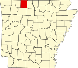
 Sugar Loaf Township Location in Arkansas | |
| Coordinates: 36°24′52.87″N 92°58′3.37″W / 36.4146861°N 92.9676028°W | |
| Country | |
| State | |
| County | Boone |
| Area | |
• Total | 93.832 sq mi (243.02 km2) |
| • Land | 84.026 sq mi (217.63 km2) |
| • Water | 9.806 sq mi (25.40 km2) |
| Population (2010) | |
• Total | 2,320 |
| • Density | 27.61/sq mi (10.66/km2) |
| Time zone | UTC-6 (CST) |
| • Summer (DST) | UTC-5 (CDT) |
| Zip Code | 72644 (Lead Hill), 72630 (Diamond City) |
| Area code | 870 |
Sugar Loaf Township is one of twenty current townships in Boone County, Arkansas, USA.[1] As of the 2010 census, its total population was 2,320.
Cities, towns, and villages
According to the United States Census Bureau, Sugar Loaf Township covers an area of 93.832 square miles (243.02 km2); 84.026 square miles (217.63 km2) of land and 9.806 square miles (25.40 km2) of water.
- Cedar Crest Estates including:
- Bull Shoals Acres
- Lakeshore Acres
- Landings North Subdivision
- Diamond City
- Lead Hill
- South Lead Hill