Tazewell, Georgia
From Wikipedia, the free encyclopedia
Tazewell, Georgia | |
|---|---|
_Tazewell,_GA.JPG) The Old Marion County Courthouse is located in Tazewell. It was built in 1848 and added to the National Register of Historic Places in 1980. | |
 Tazewell  Tazewell | |
| Coordinates: 32°22′50″N 84°26′27″W / 32.38056°N 84.44083°W | |
| Country | United States |
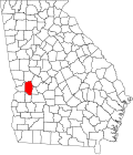
| State | Georgia |
| County | Marion |
| Area | |
• Total | 1.59 sq mi (4.1 km2) |
| • Land | 1.59 sq mi (4.1 km2) |
| • Water | 0.01 sq mi (0.026 km2) |
| Elevation | 487 ft (148 m) |
| Population | |
• Total | 93 |
| • Density | 58.6/sq mi (22.6/km2) |
| Time zone | UTC−6 (Central (CST)) |
| • Summer (DST) | UTC−5 (CDT) |
| ZIP Code | 31803 |
| FIPS code | 13-75692 |
| GNIS feature ID | 356586 |
Tazewell is an unincorporated community and census-designated place (CDP) in Marion County, in the U.S. state of Georgia.[3]
The 2020 census, listed a population of 93.[2]
A post office called Tazewell was established in 1837, and remained in operation until 1985.[4] The community was named after Henry Tazewell, a United States senator from Virginia, state legislator and judge.[5] Tazewell was named the county seat of Marion County in 1838.[6] The Old Marion County Courthouse still stands at Tazewell and was added to the National Register of Historic Places on September 18, 1980.[7]
A variant spelling was "Tazwell" (without the E).[3] The Georgia General Assembly incorporated the place as the "Town of Tazwell" in 1854.[8] Tazewell today is an unincorporated area.[3]