Tisco District
From Wikipedia, the free encyclopedia
Tisco | |
|---|---|
 Tisco's church and main plaza | |
 Tisco Location of Tisco in the Caylloma province | |
| Coordinates: 15°20′51″S 71°26′46″W / 15.3476°S 71.4461°W | |
| Country | |
| Region | Arequipa |
| Province | Caylloma |
| Capital | Tisco |
| Government | |
| • Mayor | Primitivo Sebastian Huaracha Ancca |
| Area | |
• Total | 1,445.02 km2 (557.93 sq mi) |
| Elevation | 4,188 m (13,740 ft) |
| Population | |
• Total | 2,249 |
| • Density | 1.556/km2 (4.031/sq mi) |
| Time zone | UTC-5 (PET) |
| UBIGEO | 040517 |
Tisco District is one of twenty districts of the province Caylloma in Peru.[1]
Some of the highest mountains of the district are listed below:[2]
- Allqamari
- Apachita
- Chilluma
- Chuqi Pirwa
- Chuqi Phiruru
- Chuqi Tampu
- Janq'u
- Jañuma Pirwa
- Kallka K'uchu
- Kimsa Chata
- Kiska Kiska
- Kuntur Sayana
- Laramani
- Misa Urqu
- Pirwa
- Puma Urqu
- Qillqa
- Qillwa
- Q'ara Qullu
- Q'iwiri
- Wallatani
- Wayna Kunturiri
- Wila Pukara
- Wiluma
- Wiska Apachita
- Wisk'achayuq
- Wiswillani
 Entrance to Tisco's main plaza through its gate
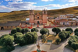 Church of San Pedro Apostol de Tisco, with Plaza in foreground
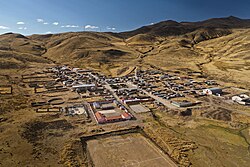 The village of Tisco as seen from the air
 The towers of Tisco's church


