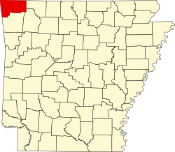
Township 1, Benton County, Arkansas
From Wikipedia, the free encyclopedia
Township 1 | |
|---|---|
  Township 1 Location in Arkansas | |
| Coordinates: 36°25′8″N 93°58′23″W / 36.41889°N 93.97306°W | |
| Country |  United States United States |
| State |  Arkansas Arkansas |
| County | Benton |
| Area | |
• Total | 130.96 sq mi (339.2 km2) |
| • Land | 116.21 sq mi (301.0 km2) |
| • Water | 14.75 sq mi (38.2 km2) 11.26% |
| Elevation | 1,380 ft (420 m) |
| Population (2010) | |
• Total | 13,223 |
| • Density | 113.8/sq mi (43.9/km2) |
| Time zone | UTC-6 (CST) |
| • Summer (DST) | UTC-5 (CDT) |
| Area code | 479 |
| GNIS feature ID | 1989186 |
| U.S. Geological Survey Geographic Names Information System: Township 1, Benton County, Arkansas | |
Township 1 is one of thirteen townships in Benton County, Arkansas, USA.[1]
- Avoca (part)
- Garfield
- Gateway
- Lost Bridge Village
- Prairie Creek
- Rogers (part)
Cemeteries
The township contains Alpine Cemetery, Bayless Cemetery, Clantonville Cemetery, Dean Cemetery, Ford Cemetery, Liberty Cemetery, McReynolds Cemetery, Ozark Cemetery, Pratt Cemetery, Scott Cemetery, Snoderley Cemetery, Walnut Hill Cemetery, and Williams Cemetery. Two former cemeteries also exist: Henson Cemetery and Williams Cemetery.
.svg)