Wenona, Georgia
From Wikipedia, the free encyclopedia
Country United States
 United States
Elevation338 ft (103 m)
Wenona, Georgia | |
|---|---|
  Wenona  Wenona | |
| Coordinates: 31°54′16″N 83°45′49″W / 31.90444°N 83.76361°W | |
| Country | United States |
| State | Georgia |
| County | Crisp |
| Area | |
• Total | 2.86 sq mi (7.42 km2) |
| • Land | 2.83 sq mi (7.34 km2) |
| • Water | 0.027 sq mi (0.07 km2) |
| Elevation | 338 ft (103 m) |
| Population (2020) | |
• Total | 231 |
| • Density | 81.5/sq mi (31.45/km2) |
| Time zone | UTC-5 (Eastern (EST)) |
| • Summer (DST) | UTC-4 (EDT) |
| ZIP Code | 31015 (Cordele) |
| Area code | 229 |
| FIPS code | 13-81208 |
| GNIS feature ID | 2812675[2] |
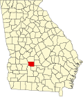
Wenona is an unincorporated community and census-designated place (CDP) in Crisp County, Georgia, United States. It is on U.S. Route 41 where it is joined by Georgia State Route 33, 4 miles (6 km) south of Cordele, the county seat, and 5 miles (8 km) north of Arabi. Interstate 75 forms the eastern border of the CDP, with access from Exit 97.
The 2020 census listed a population of 231.[3]