Werneuchen
Town in Brandenburg, Germany
From Wikipedia, the free encyclopedia
Werneuchen (German pronunciation: [vɛɐ̯ˈnɔʏçn̩] ⓘ) is a town in Brandenburg, Germany, in the district of Barnim northeast of Berlin within the metropolitan area. Most of the population of Werneuchen commutes to Berlin.[citation needed]

Werneuchen | |
|---|---|
Church in Willmersdorf | |
 Flag  Coat of arms | |
Location of Werneuchen
within Barnim district  | |
 Location of Werneuchen | |
  Werneuchen  Werneuchen | |
| Coordinates: 52°38′N 13°44′E | |
| Country | Germany |
| State | Brandenburg |
| District | Barnim |
| Subdivisions | 9 Ortsteile |
| Government | |
| • Mayor (2019–27) | Frank Kulicke[1] (Ind.) |
| Area | |
• Total | 117.01 km2 (45.18 sq mi) |
| Elevation | 75 m (246 ft) |
| Population (2024-12-31)[2] | |
• Total | 9,397 |
| • Density | 80.31/km2 (208.0/sq mi) |
| Time zone | UTC+01:00 (CET) |
| • Summer (DST) | UTC+02:00 (CEST) |
| Postal codes | 16356 |
| Dialling codes | 033398 |
| Vehicle registration | BAR |
| Website | www.stadt-werneuchen.de |

History
From 1815 to 1947, Werneuchen was part of the Prussian Province of Brandenburg, from 1947 to 1952 of the State of Brandenburg, from 1952 to 1990 of the East German Bezirk Frankfurt and since 1990 again of Brandenburg.
Demography
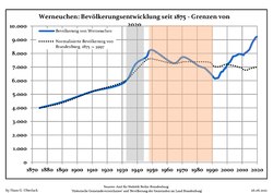 Development of population since 1875 within the current boundaries (blue line: population; dotted line: comparison to population development of Brandenburg state; grey background: time of Nazi rule; red background: time of communist rule)
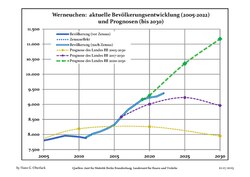 Recent population development and projections (population development before 2011 census (blue line); recent population development according to the Census in Germany in 2011 and 2022 (blue bordered line); official projection for 2024–2040 in three variants (dotted lines 2025–2040)
Werneuchen: Population development within the current boundaries (2025)[3] | |||||||||||||||||||||||||||||||||||||||||||||||||||||||||||||||||||||||
|
|
| |||||||||||||||||||||||||||||||||||||||||||||||||||||||||||||||||||||


