West Fork, Missouri
From Wikipedia, the free encyclopedia
West Fork, Missouri | |
|---|---|
 Interactive map of West Fork, Missouri | |
| Coordinates: 37°29′30″N 91°06′32″W / 37.49167°N 91.10889°W | |
| Country | United States |
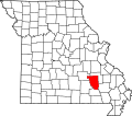
| State | Missouri |
| County | Reynolds |
West Fork is an unincorporated community in Reynolds County, in the U.S. state of Missouri.[1] The community lies on south bank of the West Fork of the Black River adjacent to the confluence of Toms Creek with the Black. The community lies approximately six miles east-northeast of Bunker on Missouri Route KK.[2]