Westmorland and Furness Way
From Wikipedia, the free encyclopedia
| Westmorland and Furness Way | |
|---|---|
 | |
| Length | 120 mi (193 km) |
| Location | Westmorland and Furness, Northern England |
| Designation | Long distance footpath announced in 2026 |
| Trailheads | Alston 54°48′36″N 2°26′28″W / 54.810°N 2.441°W Furness Abbey 54°8′7″N 3°11′52″W / 54.13528°N 3.19778°W |
| Use | Hiking |
The Westmorland and Furness Way is a forthcoming 120-mile (190 km) walking route in Westmorland and Furness, north-west England.[1] It connects Alston, in the Pennines in the north of the council area, and Furness Abbey, near Barrow-in-Furness in the south west, and passes through the North Pennines National Landscape, the Yorkshire Dales National Park and the Lake District National Park.[2]
As of January 2026[update] it was expected that the route would be launched in Autumn 2026.[3]
The route is being developed by Westmorland and Furness Council, which was established in 2023. The council says that the route will "celebrate the geography and spectacular scenery of Westmorland and Furness" and will bring visitors to the area and benefit the economy of local communities.[3]
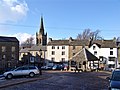 Alston town centre


