Whiting, Missouri
From Wikipedia, the free encyclopedia
Whiting, Missouri | |
|---|---|
 Interactive map of Whiting, Missouri | |
| Coordinates: 36°47′18″N 89°22′32″W / 36.78833°N 89.37556°W | |
| Country | |
| State | |
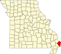
| County | Mississippi |
| Area | |
• Total | 0.26 sq mi (0.68 km2) |
| • Land | 0.26 sq mi (0.68 km2) |
| • Water | 0 sq mi (0.00 km2) |
| Elevation | 308 ft (94 m) |
| Population | |
• Total | 155 |
| • Density | 594.0/sq mi (229.36/km2) |
| ZIP Code | 63845 (East Prairie) |
| FIPS code | 29-79684 |
| GNIS feature ID | 2806415[2] |
Whiting is an unincorporated community and census-designated place in Mississippi County, in the U.S. state of Missouri.[2] As of the 2020 census, the population was 155.[3]
Geography
Whiting is in southwestern Mississippi County and is bordered to the southwest by the city of East Prairie. Missouri Route 105 is the main road through the community, leading southwest into East Prairie and north 9 miles (14 km) to Charleston, the county seat.
According to the U.S. Census Bureau, the Whiting CDP has an area of 0.26 square miles (0.67 km2), all land.[1]