Wood, Missouri
From Wikipedia, the free encyclopedia
CountryUnited States
Post office established1898
Elevation1,043 ft (318 m)
Wood
Woods | |
|---|---|
 Wood Location within Missouri  Wood Wood (the United States) | |
| Coordinates: 39°57′06″N 94°27′12″W / 39.95167°N 94.45333°W | |
| Country | United States |
| State | Missouri |
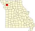
| County | DeKalb |
| Post office established | 1898 |
| Post office discontinued | 1902 |
| Elevation | 1,043 ft (318 m) |
| Time zone | UTC-6 (Central (CST)) |
| • Summer (DST) | UTC-5 (CDT) |
| GNIS feature ID | 739620[1] |
Wood (also known as Woods) is an extinct hamlet in DeKalb County, in the U.S. state of Missouri.[1]
The community is on Missouri Route H approximately 6.5 miles northwest of Maysville. Lost Creek flows past approximately one-half mile east of the community.[2]