Yeongwol County
County in South Korea
From Wikipedia, the free encyclopedia
Yeongwol County (Korean: 영월군; RR: Yeongwol-gun) is a county in the South Korean state of Gangwon. Its population is about 36,000 as of 2026.

Yeongwol
영월 | |
|---|---|
| Korean transcription(s) | |
| • Hangul | 영월군 |
| • Hanja | 寧越郡 |
| • Revised Romanization | Yeongwol-gun |
| • McCune-Reischauer | Yŏngwŏl-gun |
Miniature Shape of the Korean Peninsula | |
 Flag | |
 Location in South Korea | |
| Country | |
| State | |
| Administrative divisions | 2 eup, 7 myeon |
| Area | |
• Total | 1,127.36 km2 (435.28 sq mi) |
| Population (February 2026[1]) | |
• Total | 35,917 |
| • Density | 31.9/km2 (83/sq mi) |
| • Dialect | Gangwon |
In South Korea, it is known as the place where King Danjong, the sixth king of the Joseon Dynasty, was exiled when he was forced to abdicate by his uncle, who became King Sejo. It is also where Danjong was buried after he was murdered in 1457, following the attempts by six martyred ministers to restore him to power, after he was perceived to be a continuing threat to the rule of his uncle. It is also where the Joseon Dynasty poet Kim Sat-gat was buried.[2]
History
Originally a part of Jinhan, Yeongwol (then called Baekwol) became a part of Baekje in the 4th century. After Goguryeo invaded Baekje, it became a part of Goguryeo and was called Naesaeng-hyeon (내생현; 奈生縣). After Silla unified the three kingdoms, it was renamed Naeseong-gun (내성군; 奈城郡).
It later became a part of Goryeo and was renamed Yeongwol. In 1457, King Danjong was exiled to Yeongwol.[3]
Industry
The main agricultural products are rice, barley, corn and potatoes.
Anthracite is mined in Yeongwol-eup and Buk-myeon. Silicate mineral and pagodite are mined in Jucheon-myeon. Mica is mined in Gimsatgat-myeon. Sangdong-eup has the world's largest store of tungsten which accounted for more than half of South Korea's exports in the 1960s.[4] Mining used to flourish because there were many underground resources buried in the county due to its geological structure. However, the number of mines decreased significantly due to the coal rationalization policy and import of Chinese resources.[3]
Education
Administrative divisions
In 2009, Hadong-myeon was renamed to Gimsatgat-myeon and Seo-myeon was renamed to Hanbando-myeon. In 2016, Suju-myeon was renamed to Mureungdowon-myeon.[3]
| Name | Korean text | Area (km2) | Population (2026) | Map |
|---|---|---|---|---|
| Yeongwol-eup | 영월읍 | 172.4 | 19,240 |  |
| Sangdong-eup | 상동읍 | 139.8 | 1,009 | |
| Sansol-myeon | 산솔면 | 124.7 | 1,360 | |
| Gimsatgat-myeon | 김삿갓면 | 171.3 | 1,758 | |
| Buk-myeon | 북면 | 111.1 | 1,962 | |
| Nam-myeon | 남면 | 82.1 | 2,101 | |
| Hanbando-myeon | 한반도면 | 69.9 | 2,595 (including Ssangyong) | |
| Jucheon-myeon | 주천면 | 102.5 | 3,786 | |
| Mureungdowon-myueon | 무릉도원면 | 153.6[5] | 2,106[1] | |
| Total | 1,127.3 | 35,917 | ||
Geology

Most of Yeongwol is included in the Okcheon Belt. Joseon Supergroup and Pyeongan Supergoup which have limestone and anthracite are distributed in the region.[3]
Notable sites
- Seondol: Shaped like a cliff split with a large knife, it is designated as a scenic site.[6]
- Gossigul: Place where the Go family hid during the Imjin War, it is designated as a natural monument. It has well-developed stalactite and stalagmite and is inhabited by organisms that only live in caves.[7]
- Potholes on Yoseonam in Mureung-ri: Designated as a natural monument, it has great academic value because it shows fluvial erosion.[8]
Climate
Yeongwol has a monsoon-influenced humid continental climate (Köppen: Dwa) with cold, dry winters and hot, rainy summers.
| Climate data for Yeongwol (1995–2020 normals, extremes 1995–present) | |||||||||||||
|---|---|---|---|---|---|---|---|---|---|---|---|---|---|
| Month | Jan | Feb | Mar | Apr | May | Jun | Jul | Aug | Sep | Oct | Nov | Dec | Year |
| Record high °C (°F) | 14.1 (57.4) |
20.9 (69.6) |
26.6 (79.9) |
33.3 (91.9) |
35.3 (95.5) |
36.8 (98.2) |
38.5 (101.3) |
39.9 (103.8) |
33.6 (92.5) |
28.4 (83.1) |
25.1 (77.2) |
15.5 (59.9) |
38.7 (101.7) |
| Mean daily maximum °C (°F) | 2.5 (36.5) |
5.8 (42.4) |
11.8 (53.2) |
18.8 (65.8) |
24.4 (75.9) |
28.1 (82.6) |
29.2 (84.6) |
29.9 (85.8) |
25.5 (77.9) |
20.0 (68.0) |
11.9 (53.4) |
4.2 (39.6) |
17.7 (63.9) |
| Daily mean °C (°F) | −3.6 (25.5) |
−0.8 (30.6) |
4.9 (40.8) |
11.5 (52.7) |
17.0 (62.6) |
21.3 (70.3) |
23.9 (75.0) |
24.3 (75.7) |
19.2 (66.6) |
12.6 (54.7) |
5.3 (41.5) |
−1.7 (28.9) |
11.2 (52.2) |
| Mean daily minimum °C (°F) | −9.2 (15.4) |
−6.8 (19.8) |
−1.5 (29.3) |
4.3 (39.7) |
10.0 (50.0) |
15.6 (60.1) |
20.1 (68.2) |
20.5 (68.9) |
14.7 (58.5) |
7.1 (44.8) |
−0.1 (31.8) |
−7.0 (19.4) |
5.6 (42.1) |
| Record low °C (°F) | −23.5 (−10.3) |
−23.1 (−9.6) |
−15.5 (4.1) |
−6.9 (19.6) |
1.7 (35.1) |
4.1 (39.4) |
10.8 (51.4) |
11.5 (52.7) |
3.7 (38.7) |
−5.6 (21.9) |
−11.7 (10.9) |
−19.5 (−3.1) |
−23.5 (−10.3) |
| Average precipitation mm (inches) | 19.1 (0.75) |
28.2 (1.11) |
45.1 (1.78) |
73.5 (2.89) |
78.4 (3.09) |
137.1 (5.40) |
294.8 (11.61) |
280.4 (11.04) |
139.4 (5.49) |
49.4 (1.94) |
37.4 (1.47) |
22.3 (0.88) |
1,205.1 (47.44) |
| Average precipitation days (≥ 0.1 mm) | 6.7 | 6.3 | 8.3 | 9.0 | 8.9 | 10.2 | 16.4 | 15.1 | 10.0 | 6.2 | 8.2 | 6.8 | 112.1 |
| Average snowy days | 9.2 | 7.1 | 5.3 | 0.2 | 0.0 | 0.0 | 0.0 | 0.0 | 0.0 | 0.1 | 2.3 | 6.1 | 30.3 |
| Average relative humidity (%) | 63.5 | 59.8 | 57.8 | 55.6 | 62.6 | 69.4 | 79.8 | 79.7 | 77.7 | 74.0 | 69.6 | 67.1 | 68.1 |
| Mean monthly sunshine hours | 179.9 | 177.6 | 202.2 | 209.2 | 225.9 | 196.5 | 138.8 | 155.0 | 155.9 | 179.7 | 151.5 | 170.6 | 2,142.8 |
| Percentage possible sunshine | 58.0 | 56.6 | 52.0 | 52.6 | 48.7 | 42.6 | 29.7 | 35.5 | 41.4 | 50.3 | 50.0 | 57.7 | 46.9 |
| Source: Korea Meteorological Administration (snow and percent sunshine 1981–2010)[9][10][11] | |||||||||||||
Culture
Heritage

- Jangneung: Tomb of Danjong, it is designated as a historic site. In 2009, it was designated as a UNESCO World Heritage Site as one of the Royal Tombs of the Joseon Dynasty.[12]
- Cheongnyeongpo: Place where King Danjong was banished to, it is designated as a scenic site.[13]
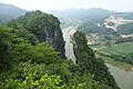
- Miniature Shape of the Korean Peninsula: Located at the end of the Pyeongchang River, it resembles the Korean Peninsula.[14]
Museums
There are 22 museums and 12 art museums such as Youngwol Y Park.[4]
Food
Chikguksu (East Asian arrowroot noodles) is well known.[15]
Festival
- Danjong Culture Festival: Festival honoring Danjong and loyalists, it has been held annually since 1967.[16]
- DongGang International Photo Festival: Held every year, it features events such as the DongGang Photography Award Exhibition, International Open Call, Photojournalists Exhibition and Gangwon Province Photographers Exhibition.[17]
Notable people
Sister cities
Gallery
 Seondol
 Gossigul
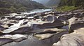 Potholes on Yoseonam in Mureung-ri
 Cheongnyeongpo
 Kim Satgat Historic Site


.jpg)
.jpg)
.jpg)