Zunil
From Wikipedia, the free encyclopedia
Zunil | |
|---|---|
Municipality | |
 Panorama, 2009 | |
 Zunil Location in Guatemala | |
| Coordinates: 14°47′N 91°29′W / 14.783°N 91.483°W | |
| Country | |
| Department | |
| Government | |
| • Mayor | Jose Maria Chaj (2012-2016) |
| Area | |
• Municipality | 80 km2 (31 sq mi) |
| Elevation | 2,076 m (6,811 ft) |
| Population (2018 census)[1] | |
• Municipality | 14,118 |
| • Density | 180/km2 (460/sq mi) |
| • Urban | 10,792 |
| Climate | Cwb |
Zunil (Spanish pronunciation: [suˈnil]) is a town and municipality in the Quetzaltenango department of Guatemala with a surface area of 80 square kilometres (31 sq mi).[2] The town of Zunil is located 9 kilometres (5.6 mi) from the city of Quetzaltenango, on the bank of the Salamá River.[3] Zunil has an altitude of approximately 2,075 metres (6,808 ft) above mean sea level.[3] The population of the municipality, which is 100% indigenous, was 14,118 at the 2018 census. The inhabitants speak Kʼicheʼ and Spanish.[2] There are thermal baths with volcanic water around the town, for example Fuentes Georginas and Almolonga.
Namesakes
A crater on Mars, which may be the source of Mars meteorites, is named after the village.[4]
Gallery
 Indoor market
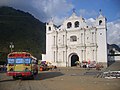 Church in Zunil
 Panorama of Zunil
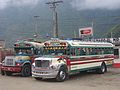 Buses in Zunil


