Thakurgaon (district)
From Wikipedia, the free encyclopedia
Cet article est une ébauche concernant le Bangladesh.
Vous pouvez partager vos connaissances en l’améliorant (comment ?) selon les recommandations des projets correspondants.
DivisionRangpur
Thana
Municipalité
Ward
Mahallah
Union
Mauza
Village5
2
18
34
51
643
641
Municipalité
Ward
Mahallah
Union
Mauza
Village5
2
18
34
51
643
641
Population1 214 376 hab. (2001)
| Thakurgaon | |
 Localisation du district au Bangladesh | |
| Administration | |
|---|---|
| Pays | |
| Division | Rangpur |
| Thana Municipalité Ward Mahallah Union Mauza Village |
5 2 18 34 51 643 641 |
| Démographie | |
| Population | 1 214 376 hab. (2001) |
| Densité | 671 hab./km2 |
| Géographie | |
| Coordonnées | 25° 57′ nord, 88° 15′ est |
| Superficie | 180 952 ha = 1 809,52 km2 |
| Liens | |
| Site web | http://www.dcthakurgaon.gov.bd |
| modifier |
|
Thakurgaon est un district du Bangladesh[1]. Il est situé dans la division de Rangpur. La ville principale est Thakurgaon.
 The Monument of 1971 War beside Tangon River
 Shuk_River at Thakurgaon Sadar Upazila
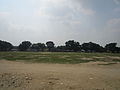 Playground of Thakurgaon
 Tangon River from Tangon Bridge
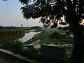 Kulik River at westside of Ranisankail Upazila
 Amai Pond at Haripur Upazila parishad
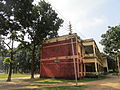 A science building of Thakurgaon Govt College.
 Nagor River at Haripur upazila
 The Backside of Haripur king's palace


Notes et références
- ↑ (en) Bangladesh Election Commission, « Constituency maps of Bangladesh » [archive], (consulté le )
| Barisal |  |
|
|---|---|---|
| Chittagong | ||
| Dhaka | ||
| Khulna | ||
| Mymensingh | ||
| Rajshahi | ||
| Rangpur | ||
| Sylhet | ||