Arabeya Valley
Valley in the Kabylie region, Algeria
From Wikipedia, the free encyclopedia
Arabeya Valley, (also known as Wadi Arabiya or Wadi Thinia Bani Aisha), is a watercourse originating from the Khachna Mountains of Algeria. It flows through the Kabylia region, eventually draining into Isser River and then into the Mediterranean Sea, passing through the Boumerdès Governorate.

| Arabeya Valley | |
|---|---|
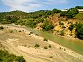
Arabeya Valley stream in the center of the city of Thenia | |
 | |
| Location | |
| Country | |
| Physical characteristics | |
| Source | Tell Atlas, Khachna, Boumerdès Province |
| • coordinates | 36.6667°N 3.6667°E |
| • elevation | 624 m (2,047 ft; 341 fathoms), Boumerdès Province: Beni Amrane |
| 2nd source | Tell Atlas, Boumerdès Province |
| • elevation | 583 m (1,913 ft; 319 fathoms), Boumerdès Province, Tidjelabine |
| Source confluence | Boumerdès Province |
| • elevation | 45 m (148 ft; 25 fathoms) |
| Mouth | Boumerdès Province: Issers |
• coordinates | 36.7258°N 3.5578°E |
• elevation | 5 m (16 ft; 2.7 fathoms), Mediterranean Sea |
| Length | 20 KM, Boumerdès Province |
| Basin size | 1.200 km2 (0.463 sq mi) |
| Basin features | |
| Landmarks | Beni Amrane, Tidjelabine, Si-Mustapha, Issers. |
Watercourse
Arabeya Valley channel is characterized by the absence of schist and soil materials in its bed.[1] This feature, shared by this watercourse along with Meraldene River, Boumerdès Valley, and Isser River, allows for the extraction of sand and gravel for use in mortar and concrete preparation.[2][3] Wadi Arabiya is considered a true corridor, with its width ranging between 5 meters and 600 meters. It gradually slopes from its intersection with Wadi Boumerdès at Mount Bouaârous in the west, heading towards its mouth in Isser River, east of the city of Thénia.[4]
The path
Arabeya Valley runs through one coastal Algerian province.[5]
| Number | Boumerdès Province |
|---|---|
| 01 | Beni Amrane |
| 02 | Tidjelabine |
| 03 | Thénia |
| 04 | Si-Mustapha |
| 05 | Issers |
Valleys
Arabeya Valley intersects with several other valleys in the Boumerdès along its course through the Khachna Mountains.[6]
| Number | Boumerdès Province |
|---|---|
| 01 | Borden Valley |
| 02 | Meraldene River |
| 03 | Boumerdès Valley |
| 04 | Bovron Valley |
| 05 | Isser River |
Dams
Arabeya Valley passes through several dams in the Boumerdès along its course through the Khachna Mountains.[7]
| Number | Boumerdès Province |
|---|---|
| 01 | Meraldene Dam |
National roads
Arabeya Valley intersects with several national roads as it crosses the Boumerdès in the Khachna Mountains.[8]
| Number | Boumerdès Province |
|---|---|
| 01 | National Road No.5 |
| 02 | National Road No.12 |
Gallery
 The course of Isser River
 The course of Isser River

.jpg)