Bad Liebenstein
From Wikipedia, the free encyclopedia
Bad Liebenstein | |
|---|---|
 Bad Liebenstein 1900 | |
 Coat of arms | |
Location of Bad Liebenstein within Wartburgkreis district 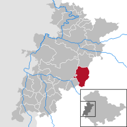 | |
 Bad Liebenstein  Bad Liebenstein | |
| Coordinates: 50°48′52″N 10°21′15″E / 50.81444°N 10.35417°E | |
| Country | Germany |
| State | Thuringia |
| District | Wartburgkreis |
| Government | |
| • Mayor (2019–25) | Michael Brodführer[1] (CDU) |
| Area | |
• Total | 48.81 km2 (18.85 sq mi) |
| Elevation | 344 m (1,129 ft) |
| Population (2024-12-31)[2] | |
• Total | 7,662 |
| • Density | 160/km2 (410/sq mi) |
| Time zone | UTC+01:00 (CET) |
| • Summer (DST) | UTC+02:00 (CEST) |
| Postal codes | 36448 |
| Dialling codes | 036961 |
| Vehicle registration | WAK |
| Website | www.bad-liebenstein.de |
Bad Liebenstein (German pronunciation: [baːt ˈliːbn̩ˌʃtaɪn] ⓘ) is a municipality and spa town in Wartburgkreis district of Thuringia, Germany.
Location
Bad Liebenstein is situated 25 km north of Meiningen, and 18 km south of Eisenach. It is located in the Mittelgebirge Thuringian Forest.
Neighbouring communities
Since the amalgamation of 1 January 2013 the town has bordered on the following communities (clockwise from the southwest): Barchfeld-Immelborn, Moorgrund and Ruhla in Wartburgkreis, Brotterode-Trusetal and Breitungen/Werra in Schmalkalden-Meiningen district.
