Bandana, Kentucky
From Wikipedia, the free encyclopedia
Bandana, Kentucky | |
|---|---|
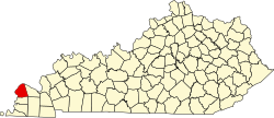
 Bandana Location within the state of Kentucky | |
| Coordinates: 37°8′40″N 88°56′32″W / 37.14444°N 88.94222°W | |
| Country | |
| State | |
| County | Ballard |
| Area | |
• Total | 1.89 sq mi (4.89 km2) |
| • Land | 1.89 sq mi (4.89 km2) |
| • Water | 0.0039 sq mi (0.01 km2) |
| Elevation | 358 ft (109 m) |
| Population (2020) | |
• Total | 177 |
| • Density | 93.8/sq mi (36.21/km2) |
| Time zone | UTC-6 (Central (CST)) |
| • Summer (DST) | UTC-5 (CDT) |
| ZIP code | 42022 |
| Area codes | 270 & 364 |
| FIPS code | 21-03412 |
| GNIS feature ID | 2629569[2] |
Bandana is a census-designated place (CDP) in Ballard County, Kentucky, United States. As of the 2020 census it had a population of 177.[3]
Geography
Bandana is located in northern Ballard County at the intersection of Kentucky Route 358 (Bandana Road) and Kentucky Route 473 (Needmore Road / Woodville Road). It is 5 miles (8 km) south of the Ohio River and 22 miles (35 km) west of Paducah.