Bapatla district
From Wikipedia, the free encyclopedia
Bapatla district | |
|---|---|
 Stupa at Bhattiprolu | |
.svg) Location of Bapatla district in Andhra Pradesh | |
 Interactive map of Bapatla district | |
| Coordinates: 15°54′18″N 80°28′05″E / 15.905°N 80.468°E | |
| Country | |
| State | Andhra Pradesh |
| Region | Kostaandhra |
| Established | 4 April 2022 |
| Revised | 31 December 2025 |
| Headquarters | Bapatla |
| Administrative divisions | |
| Government | |
| • Collector & District Magistrate | Dr.V Vinod Kumar, I.A.S. |
| • Superintendent of Police | Tushar Dudi, I.P.S. |
| • Lok Sabha constituency | Bapatla |
| • MP | Krishna Prasad Tenneti |
| • Assembly constituencies | 05 |
| Area | |
• Total | 3,828.84 km2 (1,478.32 sq mi) |
| Population (2011)[2] | |
• Total | 1,586,918 |
| • Density | 414.464/km2 (1,073.46/sq mi) |
| Time zone | UTC+05:30 (IST) |
| Website | bapatla |
Bapatla district is a district in coastal Andhra in the Indian state of Andhra Pradesh (AP) established on 4 April 2022. The administrative headquarters are in Bapatla. It has an Indian Air Force station and several universities.
Named after Bhavanarayana Swamy temple, it was originally called Bhavapuri, and later to Bhavapatla and finally, Bapatla, in due course.
History
Bapatla Taluka was created in 1794. During May 26-27, 1913 meeting of the first Andhra Mahasabha at the townhall, the foundation for separate state for Andhras was mooted.[3] During Independence movement, Chirala-Perala movement of 1919 led by Duggirala Gopalakrishnaiah became prominent at national level.[4] In 1977, a proposal to form Bapatla district was made by Kolla Venkaiah, communist leader.[citation needed]
On April 4, 2022, as part of forming districts with parliamentary constituencies as the basis, the district was created with parts from erstwhile Prakasam district and Guntur districts.[4][5][6][7][8][9][10] On 31 December 2025, five mandals of Chirala revenue division were transferred back to Prakasam District.[11]
Geography
This district is surrounded to the north by Guntur district and Palnadu district , south by the Bay of Bengal, west by the Prakasam district and east by the Krishna district.[12]
Natural resources
Sand reaches occur in Bhattiprolu and Kollur Mandals. Gravel is present in Amarthalur, Kollur, Bhattiprolu, Karlapalem and Bapatla mandals.[13]
Good deposits of coloured granites occur around Uppumaguluru and Konidena.[14]
Demographics
Based on 2011 census, Bapatla district as of the 2025 reorganisation had a population of 1,290,893, of which 284,114 (22.01%) lived in urban areas. It had a sex ratio of 1016 females per 1000 males. Scheduled Castes and Scheduled Tribes made up 284,114 (21.78%) and 62,100 (4.81%) of the population respectively.[16]
At the time of the 2011 census, 93.00% of the population spoke Telugu and 6.12% Urdu as their first language.[17] Hinduism is a majority in the district, while Christians are a significant (underreported) minority of around 15-20% in the district. Muslim make up around 7% of the population.
Administrative divisions
Cities and towns
| Ciy/Town | Civil status | Revenue Division | Population |
|---|---|---|---|
| Chirala | Municipality | Chirala | 1,62,471 |
| Bapatla | Municipality | Bapatla | 70,777 |
| Repalle | Municipality | Repalle | 50,866 |
| Martur | Nagar Panchayat | Bapatla | 21,434 |
| Inkollu | Nagar Panchayat | Chirala | 17,585 |
| Parchur | Nagar Panchayat | Bapatla | 13,375 |
Politics
Economy
Agriculture contributes to major share of gross district domestic product. Agriculture and allied services based industries such as cotton spinning mills, oil mills and shrimp processing are present in the district[20]
Irrigation
- Krishna western delta is a major irrigation project[13] Tanks, Tube Wells, Dug Wells, Lift
Irrigation are other sources of irrigation.[21]
Education
The first agricultural College in South India was started on 11 July 1945 in Bapatla by the Government of Composite Madras State India. It became part of Acharya N. G. Ranga Agricultural University, Andhra Pradesh in 1964.[13]
Military institutions
Airforce station at Suryalanka of Southern Air Command is a major defence establishment in the district. It has carried out Emergency Landing Facility trials on National Highway 16 near Addanki on 29 Dec 2022.[22]
Tourism

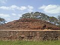 Stupa at Bhattiprolu
 Sunrise at Suryalanka Beach


Bhavanarayana Swamy Temple in Bapatla is a 5th Century CE temple dedicated to Ksheera Bhavanarayanaswamy and Sundaravalli. This temple is under the administration control of Archaeological Survey of India. Chariot procession and other festivals are celebrated.[23]
One of the earliest evidence of Brahmi script, origin of most scripts in India, is written on an urn containing Buddha's relics placed in the Stupa of Bhattiprolu. The script has been named Bhattiprolu script.[24]
Saraswata Niketanam at Vetapalem is a library founded in 1918. It is known for its large collection of palm leaf manuscripts, newspapers and books.
Beaches
Nallamada, East Tungabhadra, Gundamthippa, Romperu(right) rivers meet the sea at Kappalavaripalem, Pinniboyinavaripalem. Suryalanka beach, about 9 km from Bapatla is suitable for sea bathing. Vadarevu and Ramapuram beaches near Chirala are also popular tourist attractions.[25]