Barnardsville, North Carolina
From Wikipedia, the free encyclopedia
Barnardsville | |
|---|---|
.jpg) Barnardsville, circa 1921 | |
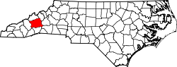
 Barnardsville Location within the state of North Carolina  Barnardsville Barnardsville (the United States) | |
| Coordinates: 35°46′55″N 82°27′20″W / 35.78194°N 82.45556°W | |
| Country | United States |
| State | North Carolina |
| County | Buncombe |
| Area | |
• Total | 3.53 sq mi (9.14 km2) |
| • Land | 3.53 sq mi (9.14 km2) |
| • Water | 0.00 sq mi (0.00 km2) |
| Elevation | 2,339 ft (713 m) |
| Population (2020) | |
• Total | 559 |
| • Density | 158.40/sq mi (61.16/km2) |
| Time zone | UTC-5 (Eastern (EST)) |
| • Summer (DST) | UTC-4 (EDT) |
| ZIP code | 28709[3] |
| Area code | 828 |
| GNIS feature ID | 2812779[2] |
Barnardsville is an unincorporated community and census-designated place (CDP) in Buncombe County, North Carolina, United States.[2] It was first listed as a CDP in the 2020 census with a population of 559.[4]
Located on Ivy Creek, the settlement is part of the Asheville Metropolitan Statistical Area.
Barnard's Inn was established at the settlement by Hezekiah and Hester Barnard in the early 1800s.[5]
A post office was established in 1875.[6]
Barnardsville incorporated in 1959, and established its own police force and fire department. The town dissolved its incorporation in 1965 for financial reasons.[6][7]