Bent Creek, Buncombe County, North Carolina
From Wikipedia, the free encyclopedia
Bent Creek, North Carolina | |
|---|---|
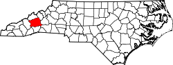
 Location in Buncombe County and the state of North Carolina | |
| Coordinates: 35°30′29″N 82°37′04″W / 35.50806°N 82.61778°W | |
| Country | United States |
| State | North Carolina |
| County | Buncombe |
| Area | |
• Total | 2.22 sq mi (5.74 km2) |
| • Land | 2.21 sq mi (5.72 km2) |
| • Water | 0.0077 sq mi (0.02 km2) |
| Elevation | 2,156 ft (657 m) |
| Population (2020) | |
• Total | 1,402 |
| • Density | 634.5/sq mi (244.97/km2) |
| Time zone | UTC-5 (Eastern (EST)) |
| • Summer (DST) | UTC-4 (EDT) |
| FIPS code | 37-05049[3] |
| GNIS feature ID | 2402683[2] |
Bent Creek is a census-designated place (CDP) in Buncombe County, North Carolina, United States. The population was 1,287 at the 2010 census.[4] The Bent Creek area has mountain bike trails within the Pisgah National Forest.
For its first 70 years, Bent Creek was "a self-sufficient community". From 1866 to 1887, Glencoe was an Episcopal mission, part of Ravenscroft Theological Training School and Associate Mission, started by Colonel L.M. Hatch, with a mill, a factory, a school and a church. It was named for "a Celtic hero's homeland." Col. Hatch's family sold 1383 acres for $5 an acre in 1900 to George Washington Vanderbilt II, who was adding a game preserve and hunting area to Biltmore Estate. The land later became part of Pisgah National Forest. Russell "Pinckney" Lance had a grist mill and had a "self-sufficient farm". Other farmers used methods intended to keep the farms operating for generations. Later, the area became Bent Creek Experimental Forest.[5][6]
Geography
The Bent Creek CDP is located in south-central Buncombe County, southwest of downtown Asheville. It is bordered to the east by North Carolina Highway 191 (Brevard Road), to the southeast by Wesley Branch Road, to the southwest by Wolf Branch (or Wolf Creek), to the northwest by the crest of Stradley Mountain, and to the north by Boring Mill Branch. The bulk of the community centers around Bent Creek Ranch Lake on Wesley Creek. The 434-acre (176 ha) North Carolina Arboretum and Bent Creek Experimental Forest are located just outside the CDP to the south of Wesley Branch Road.
According to the United States Census Bureau, the Bent Creek CDP has a total area of 2.2 square miles (5.7 km2), of which 0.008 square miles (0.02 km2), or 0.35%, is water.[4]
Climate
| Climate data for Bent Creek, Buncombe County, North Carolina, 1991–2020 normals, extremes 1949–present | |||||||||||||
|---|---|---|---|---|---|---|---|---|---|---|---|---|---|
| Month | Jan | Feb | Mar | Apr | May | Jun | Jul | Aug | Sep | Oct | Nov | Dec | Year |
| Record high °F (°C) | 82 (28) |
81 (27) |
89 (32) |
90 (32) |
91 (33) |
98 (37) |
98 (37) |
100 (38) |
97 (36) |
89 (32) |
83 (28) |
76 (24) |
100 (38) |
| Mean maximum °F (°C) | 65.6 (18.7) |
69.2 (20.7) |
77.0 (25.0) |
83.4 (28.6) |
86.0 (30.0) |
89.1 (31.7) |
90.9 (32.7) |
89.9 (32.2) |
87.0 (30.6) |
81.5 (27.5) |
73.0 (22.8) |
66.8 (19.3) |
91.8 (33.2) |
| Mean daily maximum °F (°C) | 46.3 (7.9) |
50.6 (10.3) |
58.0 (14.4) |
67.7 (19.8) |
74.9 (23.8) |
81.0 (27.2) |
84.0 (28.9) |
83.0 (28.3) |
77.2 (25.1) |
68.0 (20.0) |
57.4 (14.1) |
49.0 (9.4) |
66.4 (19.1) |
| Daily mean °F (°C) | 35.4 (1.9) |
38.4 (3.6) |
45.0 (7.2) |
53.8 (12.1) |
62.3 (16.8) |
69.4 (20.8) |
72.9 (22.7) |
71.8 (22.1) |
65.8 (18.8) |
55.2 (12.9) |
44.5 (6.9) |
38.1 (3.4) |
54.4 (12.4) |
| Mean daily minimum °F (°C) | 24.5 (−4.2) |
26.1 (−3.3) |
32.0 (0.0) |
39.8 (4.3) |
49.8 (9.9) |
57.8 (14.3) |
61.7 (16.5) |
60.6 (15.9) |
54.4 (12.4) |
42.5 (5.8) |
31.5 (−0.3) |
27.2 (−2.7) |
42.3 (5.7) |
| Mean minimum °F (°C) | 7.1 (−13.8) |
12.7 (−10.7) |
17.7 (−7.9) |
27.0 (−2.8) |
34.6 (1.4) |
46.7 (8.2) |
54.1 (12.3) |
52.1 (11.2) |
41.4 (5.2) |
27.7 (−2.4) |
19.0 (−7.2) |
13.3 (−10.4) |
4.8 (−15.1) |
| Record low °F (°C) | −16 (−27) |
−5 (−21) |
−1 (−18) |
17 (−8) |
26 (−3) |
33 (1) |
40 (4) |
38 (3) |
29 (−2) |
15 (−9) |
−1 (−18) |
−9 (−23) |
−16 (−27) |
| Average precipitation inches (mm) | 4.50 (114) |
3.57 (91) |
4.64 (118) |
4.46 (113) |
4.12 (105) |
4.75 (121) |
5.19 (132) |
4.13 (105) |
4.74 (120) |
3.64 (92) |
4.07 (103) |
4.20 (107) |
52.01 (1,321) |
| Average snowfall inches (cm) | 1.7 (4.3) |
0.4 (1.0) |
1.3 (3.3) |
0.0 (0.0) |
0.0 (0.0) |
0.0 (0.0) |
0.0 (0.0) |
0.0 (0.0) |
0.0 (0.0) |
0.0 (0.0) |
0.0 (0.0) |
0.6 (1.5) |
4.0 (10) |
| Average precipitation days (≥ 0.01 in) | 10.2 | 9.5 | 11.8 | 10.3 | 9.9 | 13.0 | 12.6 | 12.0 | 8.6 | 6.7 | 8.1 | 9.9 | 122.6 |
| Average snowy days (≥ 0.1 in) | 0.5 | 0.6 | 0.3 | 0.1 | 0.0 | 0.0 | 0.0 | 0.0 | 0.0 | 0.0 | 0.0 | 0.3 | 1.8 |
| Source 1: NOAA[7] | |||||||||||||
| Source 2: National Weather Service[8] | |||||||||||||