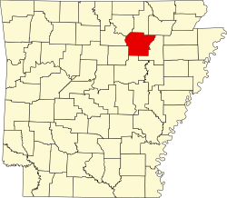
Barren Township, Independence County, Arkansas
From Wikipedia, the free encyclopedia
Barren Township | |
|---|---|
  Barren Township Location in Arkansas  Barren Township Barren Township (the United States) | |
| Coordinates: 35°53′59″N 91°32′32″W / 35.899617°N 91.542150°W[1] | |
| Country | United States |
| State | Arkansas |
| County | Independence |
| Area | |
• Total | 40.548 sq mi (105.02 km2) |
| • Land | 40.456 sq mi (104.78 km2) |
| • Water | 0.092 sq mi (0.24 km2) |
| Elevation | 548 ft (167 m) |
| Population | |
• Total | 1,483 |
| • Density | 36.66/sq mi (14.15/km2) |
| Time zone | UTC-6 (CST) |
| • Summer (DST) | UTC-5 (CDT) |
| FIPS code[2][3] | 05-90123 |
| GNIS ID[2][3] | 68757 |
Barren Township is a township in Independence County, Arkansas, United States.[4] Its total population was 1,483 as of the 2010 United States census,[1][5] an increase of 17.79 percent from 1,259 at the 2000 census.[6][7]

According to the 2010 Census, Barren Township is located at 35°53′59″N 91°32′32″W / 35.899617°N 91.542150°W (35.899617, -91.542150).[1] It has a total area of 40.548 square miles (105.02 square kilometers), of which 40.456 sq mi (104.78 km2) is land and 0.092 sq mi (0.24 km2) is water (0.23%).[1] As per the USGS National Elevation Dataset, the elevation is 548 feet (167 m).[2]