Bozel
From Wikipedia, the free encyclopedia
Bozel
| |
|---|---|
 The church and surrounding buildings in Bozel | |
 Location of Bozel | |
 Bozel  Bozel | |
| Coordinates: 45°27′08″N 6°38′56″E / 45.4522°N 6.6488°E | |
| Country | France |
| Region | Auvergne-Rhône-Alpes |
| Department | Savoie |
| Arrondissement | Albertville |
| Canton | Moûtiers |
| Intercommunality | Val Vanoise |
| Government | |
| • Mayor (2020–2026) | Sylvain Pulcini[1] |
Area 1 | 28.8 km2 (11.1 sq mi) |
| Population (2023)[2] | 2,098 |
| • Density | 72.8/km2 (189/sq mi) |
| Time zone | UTC+01:00 (CET) |
| • Summer (DST) | UTC+02:00 (CEST) |
| INSEE/Postal code | 73055 /73350 |
| Elevation | 746–2,589 m (2,448–8,494 ft) (avg. 768 m or 2,520 ft) |
| Website | www.ot-bozel.com, www.bozelinfo.com |
| 1 French Land Register data, which excludes lakes, ponds, glaciers > 1 km2 (0.386 sq mi or 247 acres) and river estuaries. | |
Bozel (French pronunciation: [bɔzɛl]; Arpitan Savoyard: Bosél or Bozél) is a commune in the Savoie department in the Auvergne-Rhône-Alpes region in Southeastern France.
Bozel acts as a base village for the largest ski area in the world, Les Trois Vallées. Specifically in the valley of Courchevel. Bozel does not yet have a lift of any sort or any ski runs as it lies at 870m above sea level. However, there are constant discussions and rumours that the town will get its own gondola lift which will go up to the village of Le Praz at 1060m. Le Praz has lifts and ski runs of its own which connect it to the main town of the Courchevel valley; Courchevel 1850.
In the course of the French Revolution, it was briefly renamed Fructidor.
| Year | Pop. | ±% p.a. |
|---|---|---|
| 1968 | 1,380 | — |
| 1975 | 1,344 | −0.38% |
| 1982 | 1,504 | +1.62% |
| 1990 | 1,690 | +1.47% |
| 1999 | 1,854 | +1.03% |
| 2007 | 1,992 | +0.90% |
| 2012 | 2,019 | +0.27% |
| 2017 | 1,841 | −1.83% |
| 2023 | 2,098 | +2.20% |
| Source: INSEE[3] | ||
Gallery
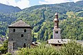 Tour de Bozel and Église Saint-François-de-Sales
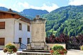 Monument aux morts
.jpg)
.jpg)