Cerro Gordo Township, Piatt County, Illinois
From Wikipedia, the free encyclopedia
Cerro Gordo Township | |
|---|---|
 Location in Piatt County | |
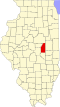
 Piatt County's location in Illinois | |
| Coordinates: 39°51′N 88°41′W / 39.850°N 88.683°W | |
| Country | United States |
| State | Illinois |
| County | Piatt |
| Established | November 8, 1859 |
| Area | |
• Total | 60.26 sq mi (156.1 km2) |
| • Land | 60.26 sq mi (156.1 km2) |
| • Water | 0 sq mi (0 km2) 0% |
| Elevation | 702 ft (214 m) |
| Population (2010) | |
| 1,999 | |
| • Density | 34/sq mi (13/km2) |
| Time zone | UTC-6 (CST) |
| • Summer (DST) | UTC-5 (CDT) |
| FIPS code | 17-147-12275 |
Cerro Gordo Township is a township in Piatt County, Illinois, USA. As of the 2010 census, its population was 2,046 and it contained 874 housing units.[2]
Cities and towns
According to the 2010 census, the township has a total area of 60.26 square miles (156.1 km2), all land.[2]
Unincorporated towns
Extinct towns
- Burrowsville
- Lintner
Adjacent townships
- Willow Branch Township (north)
- Bement Township (northeast)
- Unity Township (east)
- Lovington Township, Moultrie County (south)
- Dora Township, Moultrie County (southwest)
- Long Creek Township, Macon County (west)
- Oakley Township, Macon County (west)
Cemeteries
The township contains four cemeteries: Cerro Gordo, Clover, County and LaPlace.
Major highways
Airports and landing strips
- White Landing Strip