Charlestown (CDP), New Hampshire
From Wikipedia, the free encyclopedia
Charlestown, New Hampshire | |
|---|---|
 Main Street | |
 Charlestown  Charlestown | |
| Coordinates: 43°14′08″N 72°25′25″W / 43.23556°N 72.42361°W | |
| Country | United States |
| State | New Hampshire |
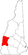
| County | Sullivan |
| Town | Charlestown |
| Area | |
• Total | 1.00 sq mi (2.59 km2) |
| • Land | 0.95 sq mi (2.47 km2) |
| • Water | 0.046 sq mi (0.12 km2) |
| Elevation | 387 ft (118 m) |
| Population (2020) | |
• Total | 1,078 |
| • Density | 1,131.4/sq mi (436.83/km2) |
| Time zone | UTC-5 (Eastern (EST)) |
| • Summer (DST) | UTC-4 (EDT) |
| ZIP code | 03603 |
| Area code | 603 |
| FIPS code | 33-11300 |
| GNIS feature ID | 2378055[2] |
Charlestown is a census-designated place (CDP) and the main village in the town of Charlestown, New Hampshire, United States. The population of the CDP was 1,078 at the 2020 census,[3] out of 4,806 in the entire town.