Newport (CDP), New Hampshire
From Wikipedia, the free encyclopedia
Newport, New Hampshire | |
|---|---|
 Newport, NH, from the south | |
 Newport  Newport | |
| Coordinates: 43°21′54″N 72°10′36″W / 43.36500°N 72.17667°W | |
| Country | United States |
| State | New Hampshire |
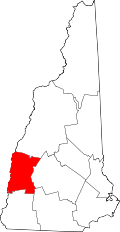
| County | Sullivan |
| Town | Newport |
| Area | |
• Total | 14.11 sq mi (36.54 km2) |
| • Land | 14.11 sq mi (36.54 km2) |
| • Water | 0 sq mi (0.00 km2) |
| Elevation | 797 ft (243 m) |
| Population (2020) | |
• Total | 4,735 |
| • Density | 335.6/sq mi (129.59/km2) |
| Time zone | UTC-5 (Eastern (EST)) |
| • Summer (DST) | UTC-4 (EDT) |
| ZIP code | 03773 |
| Area code | 603 |
| FIPS code | 33-52500 |
| GNIS feature ID | 2378084[2] |
Newport is a census-designated place (CDP) comprising the main village and surrounding rural land in the town of Newport, Sullivan County, New Hampshire, United States. The population of the CDP was 4,735 at the 2020 census,[3] out of 6,299 in the entire town.