Chisel Peak (Park Ranges)
Mountain in British Columbia, Canada
From Wikipedia, the free encyclopedia
Chisel Peak is the descriptive name for a remote 3,046-metre (9,993-foot) chisel-shaped mountain summit located above the south shore of Fortress Lake in Hamber Provincial Park in the Canadian Rockies of British Columbia, Canada.[3] Its nearest higher peak is Ghost Mountain, 5.9 km (3.7 mi) to the southwest.[1] The Chaba Icefield lies 8 km (5 mi) to the south, and the Continental Divide is 6 km (4 mi) to the east.

| Chisel Peak | |
|---|---|
Chisel Peak seen from Fortress Lake | |
| Highest point | |
| Elevation | 3,046 m (9,993 ft)[1][a] |
| Prominence | 726 m (2,382 ft)[1] |
| Parent peak | Ghost Mountain (3203 m)[1] |
| Listing | Mountains of British Columbia |
| Coordinates | 52°21′00″N 117°49′50″W[4] |
| Geography | |
  Chisel Peak Location in British Columbia  Chisel Peak Location in Canada | |
 | |
| Interactive map of Chisel Peak | |
Country | Canada |
Province | British Columbia |
District | Kootenay Land District[5] |
Protected area | Hamber Provincial Park |
| Parent range | Park Ranges[1] |
| Topo map | NTS 83C5 Fortress Lake[4] |
| Climbing | |
| First ascent | 1920 Interprovincial Boundary Commission[1][2] |
Geology
Chisel Peak is composed of sedimentary rock laid down during the Precambrian to Cambrian periods and pushed east and over the top of younger rock during the Laramide orogeny.[6]
Climate
Based on the Köppen climate classification, Chisel Peak is located in a subarctic climate with cold, snowy winters, and mild summers.[7] Temperatures can drop below −20 °C with wind chill factors below −30 °C. The months July through September offer the most favorable weather for viewing and climbing.
Gallery
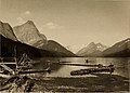 Chisel Peak by Walter Wilcox 1909
_(14761365754).jpg)

