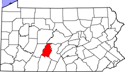
East Freedom, Pennsylvania
From Wikipedia, the free encyclopedia
East Freedom, Pennsylvania | |
|---|---|
 Interactive map of East Freedom, Pennsylvania | |
| Coordinates: 40°21′19″N 78°25′50″W / 40.35528°N 78.43056°W | |
| Country | United States |
| State | Pennsylvania |
| County | Blair |
| Township | Freedom |
| Area | |
• Total | 0.49 sq mi (1.28 km2) |
| • Land | 0.49 sq mi (1.28 km2) |
| • Water | 0 sq mi (0.00 km2) |
| Elevation | 1,017 ft (310 m) |
| Population | |
• Total | 552 |
| • Density | 1,115.2/sq mi (430.59/km2) |
| Time zone | UTC-5 (Eastern (EST)) |
| • Summer (DST) | UTC-4 (EDT) |
| ZIP codes | 16637 |
| FIPS code | 42-21176 |
| GNIS feature ID | 2631260[2] |
East Freedom is a census-designated place (CDP) in Freedom Township, Blair County, Pennsylvania, United States. It is located near I-99 and is approximately four miles to the west of the borough of Roaring Spring. As of the 2010 census, the population was 972 residents.